You are here: Home > Network List > TA - USArray Transportable Network (new EarthScope stations) Stations List
> Station 335A Moody, TX, USA > Earthquake Result Viewer
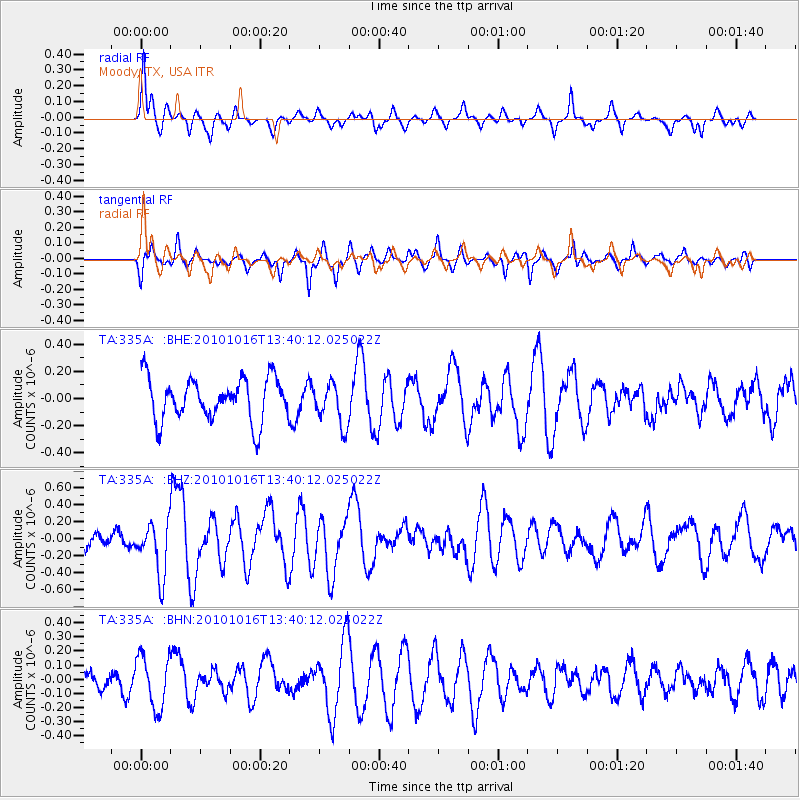
335A Moody, TX, USA - Earthquake Result Viewer
*The percent match for this event was below the threshold and hence no stack was calculated.
| Earthquake location: |
Tonga Islands |
| Earthquake latitude/longitude: |
-20.5/-173.9 |
| Earthquake time(UTC): |
2010/10/16 (289) 13:27:45 GMT |
| Earthquake Depth: |
7.4 km |
| Earthquake Magnitude: |
5.7 MB, 5.7 MS, 5.6 MW, 5.6 MW |
| Earthquake Catalog/Contributor: |
WHDF/NEIC |
|
| Network: |
TA USArray Transportable Network (new EarthScope stations) |
| Station: |
335A Moody, TX, USA |
| Lat/Lon: |
31.28 N/97.43 W |
| Elevation: |
217 m |
|
| Distance: |
89.5 deg |
| Az: |
56.356 deg |
| Baz: |
245.75 deg |
| Ray Param: |
$rayparam |
*The percent match for this event was below the threshold and hence was not used in the summary stack. |
|
| Radial Match: |
70.027176 % |
| Radial Bump: |
335 |
| Transverse Match: |
64.18376 % |
| Transverse Bump: |
395 |
| SOD ConfigId: |
339645 |
| Insert Time: |
2011-02-17 07:53:20.256 +0000 |
| GWidth: |
2.5 |
| Max Bumps: |
400 |
| Tol: |
0.001 |
|
Signal To Noise
| Channel | StoN | STA | LTA |
| TA:335A: :BHZ:20101016T13:40:12.025022Z | 3.0825796 | 3.1273544E-7 | 1.0145251E-7 |
| TA:335A: :BHN:20101016T13:40:12.025022Z | 2.2981682 | 1.8224445E-7 | 7.929987E-8 |
| TA:335A: :BHE:20101016T13:40:12.025022Z | 0.98757863 | 1.5382096E-7 | 1.5575566E-7 |
| Arrivals |
| Ps | |
| PpPs | |
| PsPs/PpSs | |


