You are here: Home > Network List > RV - Regional Alberta Seismic Observatory for Earthquake Studies Network Stations List
> Station PECRA Peace River, AB > Earthquake Result Viewer
PECRA Peace River, AB - Earthquake Result Viewer
| Earthquake location: |
Mariana Islands |
| Earthquake latitude/longitude: |
19.1/145.4 |
| Earthquake time(UTC): |
2024/04/05 (096) 11:03:16 GMT |
| Earthquake Depth: |
222 km |
| Earthquake Magnitude: |
6.8 mww |
| Earthquake Catalog/Contributor: |
NEIC PDE/us |
|
| Network: |
RV Regional Alberta Seismic Observatory for Earthquake Studies Network |
| Station: |
PECRA Peace River, AB |
| Lat/Lon: |
56.30 N/117.03 W |
| Elevation: |
592 m |
|
| Distance: |
78.4 deg |
| Az: |
34.337 deg |
| Baz: |
286.912 deg |
| Ray Param: |
0.04908135 |
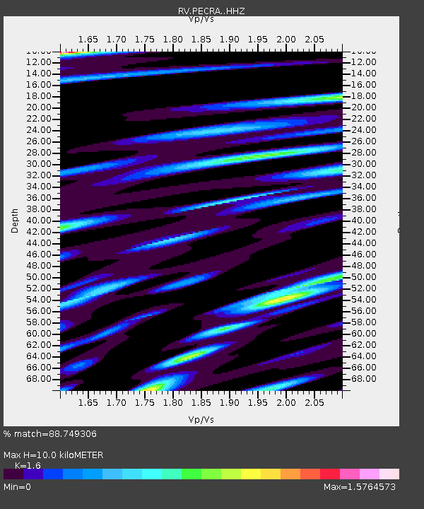
| Estimated Moho Depth: |
10.0 km |
| Estimated Crust Vp/Vs: |
1.60 |
| Assumed Crust Vp: |
6.444 km/s |
| Estimated Crust Vs: |
4.027 km/s |
| Estimated Crust Poisson's Ratio: |
0.18 |
|
| Radial Match: |
88.749306 % |
| Radial Bump: |
367 |
| Transverse Match: |
84.50198 % |
| Transverse Bump: |
400 |
| SOD ConfigId: |
34025071 |
| Insert Time: |
2024-04-19 11:33:17.661 +0000 |
| GWidth: |
2.5 |
| Max Bumps: |
400 |
| Tol: |
0.001 |
|

Signal To Noise
| Channel | StoN | STA | LTA |
| RV:PECRA: :HHZ:20240405T11:14:21.360016Z | 48.379326 | 1.5086438E-5 | 3.1183646E-7 |
| RV:PECRA: :HHN:20240405T11:14:21.360016Z | 8.039916 | 2.9276698E-6 | 3.6414184E-7 |
| RV:PECRA: :HHE:20240405T11:14:21.360016Z | 18.744364 | 7.5996236E-6 | 4.0543512E-7 |
| Arrivals |
| Ps | 1.0 SECOND |
| PpPs | 3.9 SECOND |
| PsPs/PpSs | 4.9 SECOND |


