You are here: Home > Network List > S1 - Australian Seismometers in Schools Stations List
> Station AUKUL Kulin District High School > Earthquake Result Viewer
AUKUL Kulin District High School - Earthquake Result Viewer
| Earthquake location: |
Mariana Islands |
| Earthquake latitude/longitude: |
19.1/145.4 |
| Earthquake time(UTC): |
2024/04/05 (096) 11:03:16 GMT |
| Earthquake Depth: |
222 km |
| Earthquake Magnitude: |
6.8 mww |
| Earthquake Catalog/Contributor: |
NEIC PDE/us |
|
| Network: |
S1 Australian Seismometers in Schools |
| Station: |
AUKUL Kulin District High School |
| Lat/Lon: |
32.67 S/118.15 E |
| Elevation: |
312 m |
|
| Distance: |
57.7 deg |
| Az: |
207.172 deg |
| Baz: |
30.796 deg |
| Ray Param: |
0.06258238 |
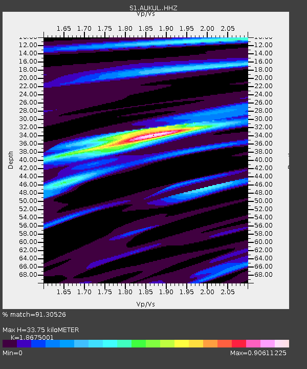
| Estimated Moho Depth: |
33.75 km |
| Estimated Crust Vp/Vs: |
1.87 |
| Assumed Crust Vp: |
6.464 km/s |
| Estimated Crust Vs: |
3.461 km/s |
| Estimated Crust Poisson's Ratio: |
0.30 |
|
| Radial Match: |
91.30526 % |
| Radial Bump: |
190 |
| Transverse Match: |
69.13547 % |
| Transverse Bump: |
400 |
| SOD ConfigId: |
34025071 |
| Insert Time: |
2024-04-19 11:33:54.658 +0000 |
| GWidth: |
2.5 |
| Max Bumps: |
400 |
| Tol: |
0.001 |
|

Signal To Noise
| Channel | StoN | STA | LTA |
| S1:AUKUL: :HHZ:20240405T11:12:12.970001Z | 141.10536 | 3.4285433E-5 | 2.4297753E-7 |
| S1:AUKUL: :HHN:20240405T11:12:12.970001Z | 36.524937 | 1.5538544E-5 | 4.2542288E-7 |
| S1:AUKUL: :HHE:20240405T11:12:12.970001Z | 38.114067 | 1.2935262E-5 | 3.3938286E-7 |
| Arrivals |
| Ps | 4.7 SECOND |
| PpPs | 14 SECOND |
| PsPs/PpSs | 19 SECOND |


