You are here: Home > Network List > SC - New Mexico Tech Seismic Network Stations List
> Station CL7 WIPP Site, New Mexico > Earthquake Result Viewer
CL7 WIPP Site, New Mexico - Earthquake Result Viewer
| Earthquake location: |
Mariana Islands |
| Earthquake latitude/longitude: |
19.1/145.4 |
| Earthquake time(UTC): |
2024/04/05 (096) 11:03:16 GMT |
| Earthquake Depth: |
222 km |
| Earthquake Magnitude: |
6.8 mww |
| Earthquake Catalog/Contributor: |
NEIC PDE/us |
|
| Network: |
SC New Mexico Tech Seismic Network |
| Station: |
CL7 WIPP Site, New Mexico |
| Lat/Lon: |
32.41 N/103.81 W |
| Elevation: |
1034 m |
|
| Distance: |
96.3 deg |
| Az: |
52.708 deg |
| Baz: |
297.203 deg |
| Ray Param: |
0.040347077 |
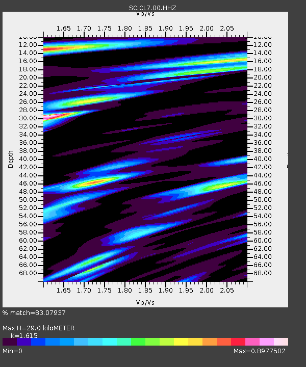
| Estimated Moho Depth: |
29.0 km |
| Estimated Crust Vp/Vs: |
1.62 |
| Assumed Crust Vp: |
6.129 km/s |
| Estimated Crust Vs: |
3.795 km/s |
| Estimated Crust Poisson's Ratio: |
0.19 |
|
| Radial Match: |
83.07937 % |
| Radial Bump: |
400 |
| Transverse Match: |
70.410576 % |
| Transverse Bump: |
400 |
| SOD ConfigId: |
34025071 |
| Insert Time: |
2024-04-19 11:34:42.334 +0000 |
| GWidth: |
2.5 |
| Max Bumps: |
400 |
| Tol: |
0.001 |
|

Signal To Noise
| Channel | StoN | STA | LTA |
| SC:CL7:00:HHZ:20240405T11:15:48.204986Z | 55.591587 | 6.869158E-7 | 1.2356471E-8 |
| SC:CL7:00:HHN:20240405T11:15:48.204986Z | 5.2352905 | 9.700862E-8 | 1.852975E-8 |
| SC:CL7:00:HHE:20240405T11:15:48.204986Z | 8.207206 | 1.348516E-7 | 1.6430878E-8 |
| Arrivals |
| Ps | 3.0 SECOND |
| PpPs | 12 SECOND |
| PsPs/PpSs | 15 SECOND |


