You are here: Home > Network List > TX - Texas Seismological Network Stations List
> Station PB13 Reeves - Culberson Border > Earthquake Result Viewer
PB13 Reeves - Culberson Border - Earthquake Result Viewer
| Earthquake location: |
Mariana Islands |
| Earthquake latitude/longitude: |
19.1/145.4 |
| Earthquake time(UTC): |
2024/04/05 (096) 11:03:16 GMT |
| Earthquake Depth: |
222 km |
| Earthquake Magnitude: |
6.8 mww |
| Earthquake Catalog/Contributor: |
NEIC PDE/us |
|
| Network: |
TX Texas Seismological Network |
| Station: |
PB13 Reeves - Culberson Border |
| Lat/Lon: |
31.55 N/103.85 W |
| Elevation: |
956 m |
|
| Distance: |
96.7 deg |
| Az: |
53.489 deg |
| Baz: |
297.094 deg |
| Ray Param: |
0.04023749 |
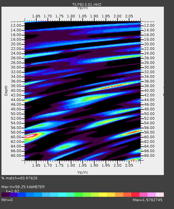
| Estimated Moho Depth: |
59.25 km |
| Estimated Crust Vp/Vs: |
1.62 |
| Assumed Crust Vp: |
6.121 km/s |
| Estimated Crust Vs: |
3.778 km/s |
| Estimated Crust Poisson's Ratio: |
0.19 |
|
| Radial Match: |
80.97628 % |
| Radial Bump: |
400 |
| Transverse Match: |
59.609337 % |
| Transverse Bump: |
400 |
| SOD ConfigId: |
34025071 |
| Insert Time: |
2024-04-19 11:36:19.910 +0000 |
| GWidth: |
2.5 |
| Max Bumps: |
400 |
| Tol: |
0.001 |
|

Signal To Noise
| Channel | StoN | STA | LTA |
| TX:PB13:01:HHZ:20240405T11:15:49.819977Z | 14.350582 | 3.4043994E-6 | 2.3723075E-7 |
| TX:PB13:01:HHN:20240405T11:15:49.819977Z | 2.3823283 | 7.219851E-7 | 3.0305858E-7 |
| TX:PB13:01:HHE:20240405T11:15:49.819977Z | 3.0335708 | 1.2776054E-6 | 4.2115562E-7 |
| Arrivals |
| Ps | 6.1 SECOND |
| PpPs | 25 SECOND |
| PsPs/PpSs | 31 SECOND |


