You are here: Home > Network List > TA - USArray Transportable Network (new EarthScope stations) Stations List
> Station C06D Leavenworth, WQ, USA > Earthquake Result Viewer
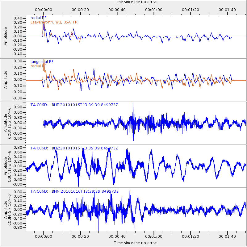
C06D Leavenworth, WQ, USA - Earthquake Result Viewer
*The percent match for this event was below the threshold and hence no stack was calculated.
| Earthquake location: |
Tonga Islands |
| Earthquake latitude/longitude: |
-20.5/-173.9 |
| Earthquake time(UTC): |
2010/10/16 (289) 13:27:45 GMT |
| Earthquake Depth: |
7.4 km |
| Earthquake Magnitude: |
5.7 MB, 5.7 MS, 5.6 MW, 5.6 MW |
| Earthquake Catalog/Contributor: |
WHDF/NEIC |
|
| Network: |
TA USArray Transportable Network (new EarthScope stations) |
| Station: |
C06D Leavenworth, WQ, USA |
| Lat/Lon: |
47.92 N/120.89 W |
| Elevation: |
544 m |
|
| Distance: |
83.0 deg |
| Az: |
32.778 deg |
| Baz: |
229.002 deg |
| Ray Param: |
$rayparam |
*The percent match for this event was below the threshold and hence was not used in the summary stack. |
|
| Radial Match: |
67.86951 % |
| Radial Bump: |
400 |
| Transverse Match: |
68.4066 % |
| Transverse Bump: |
400 |
| SOD ConfigId: |
339645 |
| Insert Time: |
2011-02-17 07:57:29.618 +0000 |
| GWidth: |
2.5 |
| Max Bumps: |
400 |
| Tol: |
0.001 |
|
Signal To Noise
| Channel | StoN | STA | LTA |
| TA:C06D: :BHZ:20101016T13:39:39.849973Z | 2.3779275 | 2.6498643E-7 | 1.1143587E-7 |
| TA:C06D: :BHN:20101016T13:39:39.849973Z | 1.0355029 | 1.4341381E-7 | 1.3849677E-7 |
| TA:C06D: :BHE:20101016T13:39:39.849973Z | 0.8198746 | 9.0479176E-8 | 1.10357334E-7 |
| Arrivals |
| Ps | |
| PpPs | |
| PsPs/PpSs | |


