You are here: Home > Network List > IU - Global Seismograph Network (GSN - IRIS/USGS) Stations List
> Station PMG Port Moresby, New Guinea > Earthquake Result Viewer
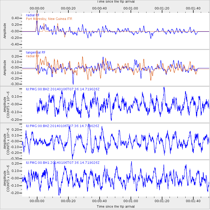
PMG Port Moresby, New Guinea - Earthquake Result Viewer
*The percent match for this event was below the threshold and hence no stack was calculated.
| Earthquake location: |
Kuril Islands |
| Earthquake latitude/longitude: |
46.2/152.1 |
| Earthquake time(UTC): |
2014/01/06 (006) 07:27:20 GMT |
| Earthquake Depth: |
100 km |
| Earthquake Magnitude: |
3.5 mb |
| Earthquake Catalog/Contributor: |
ISC/ISC |
|
| Network: |
IU Global Seismograph Network (GSN - IRIS/USGS) |
| Station: |
PMG Port Moresby, New Guinea |
| Lat/Lon: |
9.40 S/147.16 E |
| Elevation: |
90 m |
|
| Distance: |
55.5 deg |
| Az: |
185.944 deg |
| Baz: |
4.18 deg |
| Ray Param: |
$rayparam |
*The percent match for this event was below the threshold and hence was not used in the summary stack. |
|
| Radial Match: |
42.60529 % |
| Radial Bump: |
400 |
| Transverse Match: |
53.126705 % |
| Transverse Bump: |
400 |
| SOD ConfigId: |
3390531 |
| Insert Time: |
2019-04-09 21:49:16.143 +0000 |
| GWidth: |
2.5 |
| Max Bumps: |
400 |
| Tol: |
0.001 |
|
Signal To Noise
| Channel | StoN | STA | LTA |
| IU:PMG:00:BHZ:20140106T07:36:14.719026Z | 0.25517654 | 2.8693446E-8 | 1.1244546E-7 |
| IU:PMG:00:BH1:20140106T07:36:14.719026Z | 1.0831901 | 7.871277E-8 | 7.2667554E-8 |
| IU:PMG:00:BH2:20140106T07:36:14.719026Z | 1.0756835 | 8.4210285E-8 | 7.828537E-8 |
| Arrivals |
| Ps | |
| PpPs | |
| PsPs/PpSs | |


