You are here: Home > Network List > UO - University of Oregon Regional Network Stations List
> Station RANT Malin, OR, USA > Earthquake Result Viewer
RANT Malin, OR, USA - Earthquake Result Viewer
| Earthquake location: |
Mariana Islands |
| Earthquake latitude/longitude: |
19.1/145.4 |
| Earthquake time(UTC): |
2024/04/05 (096) 11:03:16 GMT |
| Earthquake Depth: |
222 km |
| Earthquake Magnitude: |
6.8 mww |
| Earthquake Catalog/Contributor: |
NEIC PDE/us |
|
| Network: |
UO University of Oregon Regional Network |
| Station: |
RANT Malin, OR, USA |
| Lat/Lon: |
42.03 N/121.28 W |
| Elevation: |
1966 m |
|
| Distance: |
79.9 deg |
| Az: |
49.07 deg |
| Baz: |
286.469 deg |
| Ray Param: |
0.048115112 |
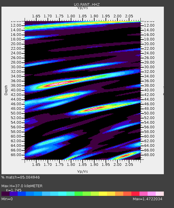
| Estimated Moho Depth: |
37.0 km |
| Estimated Crust Vp/Vs: |
1.75 |
| Assumed Crust Vp: |
6.597 km/s |
| Estimated Crust Vs: |
3.781 km/s |
| Estimated Crust Poisson's Ratio: |
0.26 |
|
| Radial Match: |
85.084946 % |
| Radial Bump: |
400 |
| Transverse Match: |
79.280014 % |
| Transverse Bump: |
400 |
| SOD ConfigId: |
34025071 |
| Insert Time: |
2024-04-19 11:37:58.216 +0000 |
| GWidth: |
2.5 |
| Max Bumps: |
400 |
| Tol: |
0.001 |
|

Signal To Noise
| Channel | StoN | STA | LTA |
| UO:RANT: :HHZ:20240405T11:14:29.050018Z | 44.155174 | 2.3098279E-5 | 5.2311606E-7 |
| UO:RANT: :HHN:20240405T11:14:29.050018Z | 1.987149 | 1.6693839E-6 | 8.400899E-7 |
| UO:RANT: :HHE:20240405T11:14:29.050018Z | 17.6839 | 9.7119655E-6 | 5.4919815E-7 |
| Arrivals |
| Ps | 4.3 SECOND |
| PpPs | 15 SECOND |
| PsPs/PpSs | 19 SECOND |


