You are here: Home > Network List > US - United States National Seismic Network Stations List
> Station NEW Newport, Washington, USA > Earthquake Result Viewer
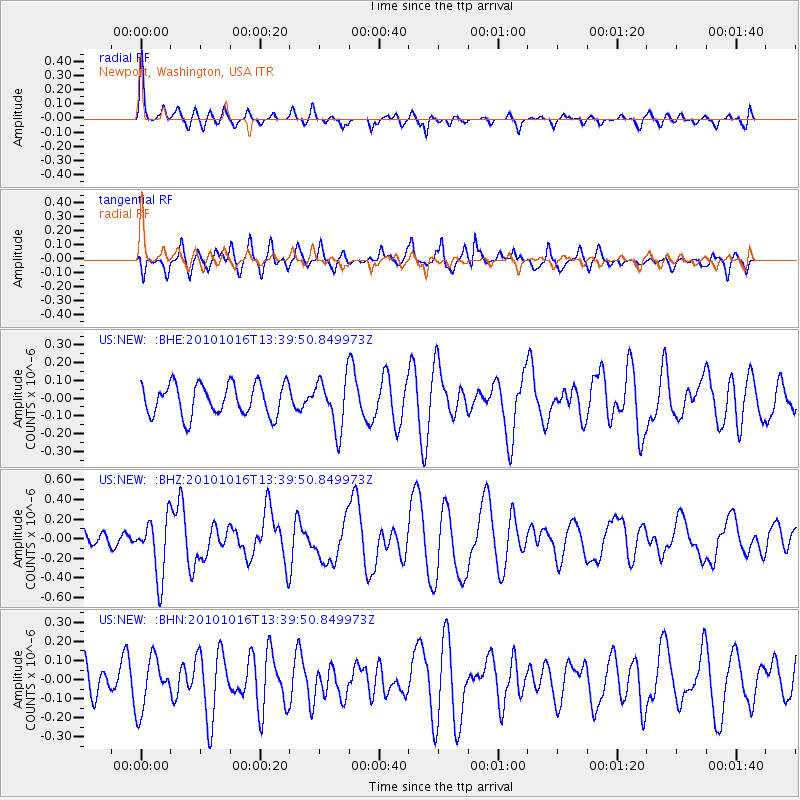
NEW Newport, Washington, USA - Earthquake Result Viewer
*The percent match for this event was below the threshold and hence no stack was calculated.
| Earthquake location: |
Tonga Islands |
| Earthquake latitude/longitude: |
-20.5/-173.9 |
| Earthquake time(UTC): |
2010/10/16 (289) 13:27:45 GMT |
| Earthquake Depth: |
7.4 km |
| Earthquake Magnitude: |
5.7 MB, 5.7 MS, 5.6 MW, 5.6 MW |
| Earthquake Catalog/Contributor: |
WHDF/NEIC |
|
| Network: |
US United States National Seismic Network |
| Station: |
NEW Newport, Washington, USA |
| Lat/Lon: |
48.26 N/117.12 W |
| Elevation: |
760 m |
|
| Distance: |
85.1 deg |
| Az: |
34.132 deg |
| Baz: |
231.944 deg |
| Ray Param: |
$rayparam |
*The percent match for this event was below the threshold and hence was not used in the summary stack. |
|
| Radial Match: |
69.4678 % |
| Radial Bump: |
288 |
| Transverse Match: |
52.504063 % |
| Transverse Bump: |
387 |
| SOD ConfigId: |
339645 |
| Insert Time: |
2011-02-17 07:58:12.859 +0000 |
| GWidth: |
2.5 |
| Max Bumps: |
400 |
| Tol: |
0.001 |
|
Signal To Noise
| Channel | StoN | STA | LTA |
| US:NEW: :BHZ:20101016T13:39:50.849973Z | 2.457293 | 3.0005484E-7 | 1.2210788E-7 |
| US:NEW: :BHN:20101016T13:39:50.849973Z | 1.4286846 | 1.3260697E-7 | 9.281753E-8 |
| US:NEW: :BHE:20101016T13:39:50.849973Z | 1.6218238 | 1.439976E-7 | 8.878745E-8 |
| Arrivals |
| Ps | |
| PpPs | |
| PsPs/PpSs | |


