You are here: Home > Network List > UU - University of Utah Regional Network Stations List
> Station GAWY Genesis Alkali Granger, WY, USA > Earthquake Result Viewer
GAWY Genesis Alkali Granger, WY, USA - Earthquake Result Viewer
| Earthquake location: |
Mariana Islands |
| Earthquake latitude/longitude: |
19.1/145.4 |
| Earthquake time(UTC): |
2024/04/05 (096) 11:03:16 GMT |
| Earthquake Depth: |
222 km |
| Earthquake Magnitude: |
6.8 mww |
| Earthquake Catalog/Contributor: |
NEIC PDE/us |
|
| Network: |
UU University of Utah Regional Network |
| Station: |
GAWY Genesis Alkali Granger, WY, USA |
| Lat/Lon: |
41.74 N/109.85 W |
| Elevation: |
2011 m |
|
| Distance: |
88.0 deg |
| Az: |
46.398 deg |
| Baz: |
293.798 deg |
| Ray Param: |
0.04241221 |
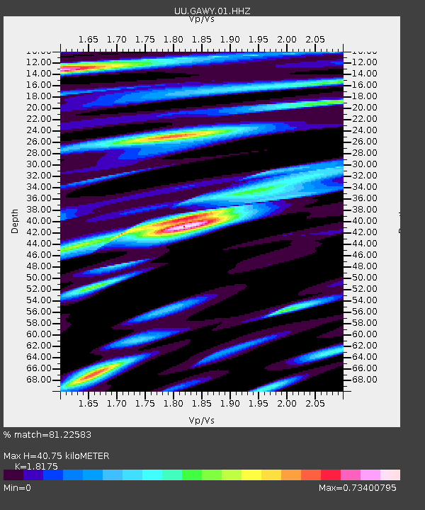
| Estimated Moho Depth: |
40.75 km |
| Estimated Crust Vp/Vs: |
1.82 |
| Assumed Crust Vp: |
6.207 km/s |
| Estimated Crust Vs: |
3.415 km/s |
| Estimated Crust Poisson's Ratio: |
0.28 |
|
| Radial Match: |
81.22583 % |
| Radial Bump: |
400 |
| Transverse Match: |
74.45437 % |
| Transverse Bump: |
400 |
| SOD ConfigId: |
34025071 |
| Insert Time: |
2024-04-19 11:40:01.246 +0000 |
| GWidth: |
2.5 |
| Max Bumps: |
400 |
| Tol: |
0.001 |
|

Signal To Noise
| Channel | StoN | STA | LTA |
| UU:GAWY:01:HHZ:20240405T11:15:09.790008Z | 50.84858 | 1.8890494E-5 | 3.7150485E-7 |
| UU:GAWY:01:HHN:20240405T11:15:09.790008Z | 3.3180003 | 7.432598E-7 | 2.2400837E-7 |
| UU:GAWY:01:HHE:20240405T11:15:09.790008Z | 8.679447 | 2.9457208E-6 | 3.3939037E-7 |
| Arrivals |
| Ps | 5.5 SECOND |
| PpPs | 18 SECOND |
| PsPs/PpSs | 24 SECOND |


