You are here: Home > Network List > UU - University of Utah Regional Network Stations List
> Station NLU North Lily, UT, USA > Earthquake Result Viewer
NLU North Lily, UT, USA - Earthquake Result Viewer
| Earthquake location: |
Mariana Islands |
| Earthquake latitude/longitude: |
19.1/145.4 |
| Earthquake time(UTC): |
2024/04/05 (096) 11:03:16 GMT |
| Earthquake Depth: |
222 km |
| Earthquake Magnitude: |
6.8 mww |
| Earthquake Catalog/Contributor: |
NEIC PDE/us |
|
| Network: |
UU University of Utah Regional Network |
| Station: |
NLU North Lily, UT, USA |
| Lat/Lon: |
39.95 N/112.07 W |
| Elevation: |
2036 m |
|
| Distance: |
87.1 deg |
| Az: |
48.703 deg |
| Baz: |
292.449 deg |
| Ray Param: |
0.04303763 |
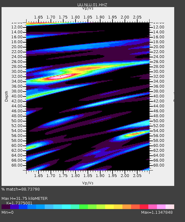
| Estimated Moho Depth: |
31.75 km |
| Estimated Crust Vp/Vs: |
1.74 |
| Assumed Crust Vp: |
6.276 km/s |
| Estimated Crust Vs: |
3.612 km/s |
| Estimated Crust Poisson's Ratio: |
0.25 |
|
| Radial Match: |
88.73798 % |
| Radial Bump: |
400 |
| Transverse Match: |
84.76885 % |
| Transverse Bump: |
400 |
| SOD ConfigId: |
34025071 |
| Insert Time: |
2024-04-19 11:40:12.384 +0000 |
| GWidth: |
2.5 |
| Max Bumps: |
400 |
| Tol: |
0.001 |
|

Signal To Noise
| Channel | StoN | STA | LTA |
| UU:NLU:01:HHZ:20240405T11:15:05.759979Z | 115.07507 | 1.15236835E-5 | 1.0014057E-7 |
| UU:NLU:01:HHN:20240405T11:15:05.759979Z | 20.22105 | 3.0168083E-6 | 1.4919148E-7 |
| UU:NLU:01:HHE:20240405T11:15:05.759979Z | 16.207527 | 2.6369532E-6 | 1.626993E-7 |
| Arrivals |
| Ps | 3.8 SECOND |
| PpPs | 14 SECOND |
| PsPs/PpSs | 17 SECOND |


