You are here: Home > Network List > US - United States National Seismic Network Stations List
> Station DGMT Dagmar, Montana, USA > Earthquake Result Viewer
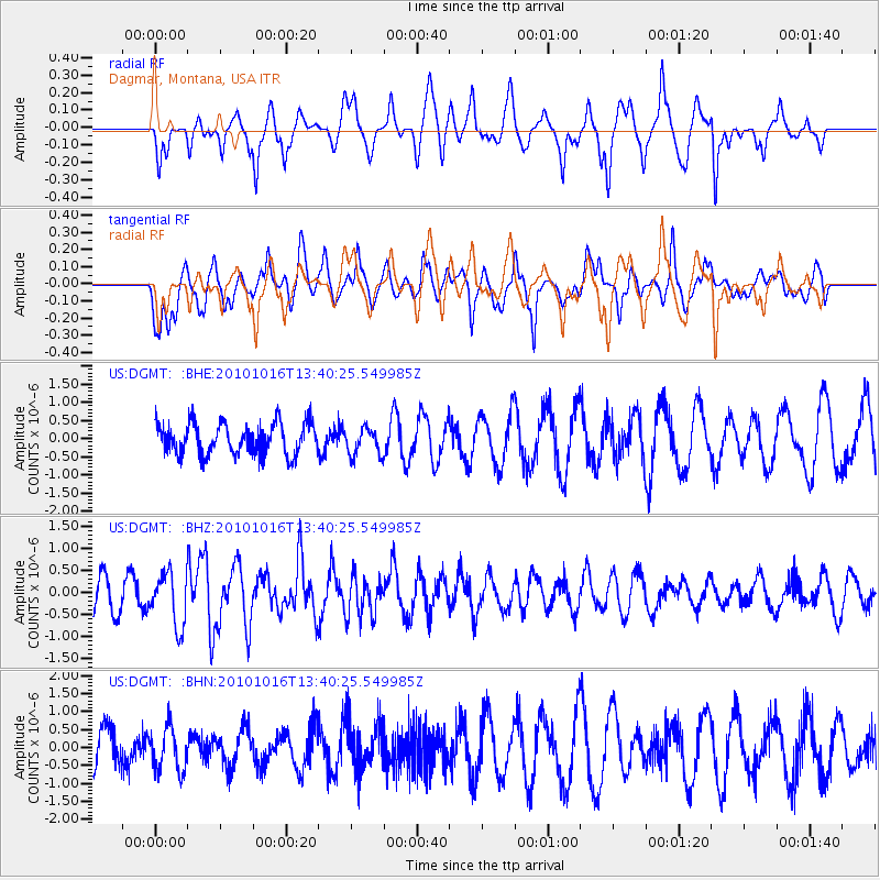
DGMT Dagmar, Montana, USA - Earthquake Result Viewer
*The percent match for this event was below the threshold and hence no stack was calculated.
| Earthquake location: |
Tonga Islands |
| Earthquake latitude/longitude: |
-20.5/-173.9 |
| Earthquake time(UTC): |
2010/10/16 (289) 13:27:45 GMT |
| Earthquake Depth: |
7.4 km |
| Earthquake Magnitude: |
5.7 MB, 5.7 MS, 5.6 MW, 5.6 MW |
| Earthquake Catalog/Contributor: |
WHDF/NEIC |
|
| Network: |
US United States National Seismic Network |
| Station: |
DGMT Dagmar, Montana, USA |
| Lat/Lon: |
48.47 N/104.20 W |
| Elevation: |
0.0 m |
|
| Distance: |
92.5 deg |
| Az: |
38.67 deg |
| Baz: |
241.688 deg |
| Ray Param: |
$rayparam |
*The percent match for this event was below the threshold and hence was not used in the summary stack. |
|
| Radial Match: |
46.56292 % |
| Radial Bump: |
321 |
| Transverse Match: |
55.320015 % |
| Transverse Bump: |
400 |
| SOD ConfigId: |
339645 |
| Insert Time: |
2011-02-17 07:59:15.282 +0000 |
| GWidth: |
2.5 |
| Max Bumps: |
400 |
| Tol: |
0.001 |
|
Signal To Noise
| Channel | StoN | STA | LTA |
| US:DGMT: :BHZ:20101016T13:40:25.549985Z | 1.8114467 | 5.9385735E-7 | 3.2783598E-7 |
| US:DGMT: :BHN:20101016T13:40:25.549985Z | 0.9224799 | 6.0649563E-7 | 6.574621E-7 |
| US:DGMT: :BHE:20101016T13:40:25.549985Z | 0.8931187 | 3.8125887E-7 | 4.2688487E-7 |
| Arrivals |
| Ps | |
| PpPs | |
| PsPs/PpSs | |


