You are here: Home > Network List > UW - Pacific Northwest Regional Seismic Network Stations List
> Station YACT Amboy, WA, USA > Earthquake Result Viewer
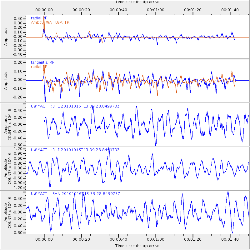
YACT Amboy, WA, USA - Earthquake Result Viewer
*The percent match for this event was below the threshold and hence no stack was calculated.
| Earthquake location: |
Tonga Islands |
| Earthquake latitude/longitude: |
-20.5/-173.9 |
| Earthquake time(UTC): |
2010/10/16 (289) 13:27:45 GMT |
| Earthquake Depth: |
7.4 km |
| Earthquake Magnitude: |
5.7 MB, 5.7 MS, 5.6 MW, 5.6 MW |
| Earthquake Catalog/Contributor: |
WHDF/NEIC |
|
| Network: |
UW Pacific Northwest Regional Seismic Network |
| Station: |
YACT Amboy, WA, USA |
| Lat/Lon: |
45.93 N/122.42 W |
| Elevation: |
211 m |
|
| Distance: |
80.9 deg |
| Az: |
33.584 deg |
| Baz: |
228.005 deg |
| Ray Param: |
$rayparam |
*The percent match for this event was below the threshold and hence was not used in the summary stack. |
|
| Radial Match: |
50.164482 % |
| Radial Bump: |
400 |
| Transverse Match: |
62.45205 % |
| Transverse Bump: |
400 |
| SOD ConfigId: |
339645 |
| Insert Time: |
2011-02-17 08:00:00.420 +0000 |
| GWidth: |
2.5 |
| Max Bumps: |
400 |
| Tol: |
0.001 |
|
Signal To Noise
| Channel | StoN | STA | LTA |
| UW:YACT: :BHZ:20101016T13:39:28.849973Z | 2.821447 | 5.1312594E-7 | 1.8186623E-7 |
| UW:YACT: :BHN:20101016T13:39:28.849973Z | 1.7415376 | 3.0352896E-7 | 1.7428792E-7 |
| UW:YACT: :BHE:20101016T13:39:28.849973Z | 0.6148099 | 1.1194379E-7 | 1.8207872E-7 |
| Arrivals |
| Ps | |
| PpPs | |
| PsPs/PpSs | |


