You are here: Home > Network List > UW - Pacific Northwest Regional Seismic Network Stations List
> Station IZEE Izee, OR, USA > Earthquake Result Viewer
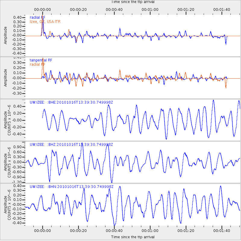
IZEE Izee, OR, USA - Earthquake Result Viewer
*The percent match for this event was below the threshold and hence no stack was calculated.
| Earthquake location: |
Tonga Islands |
| Earthquake latitude/longitude: |
-20.5/-173.9 |
| Earthquake time(UTC): |
2010/10/16 (289) 13:27:45 GMT |
| Earthquake Depth: |
7.4 km |
| Earthquake Magnitude: |
5.7 MB, 5.7 MS, 5.6 MW, 5.6 MW |
| Earthquake Catalog/Contributor: |
WHDF/NEIC |
|
| Network: |
UW Pacific Northwest Regional Seismic Network |
| Station: |
IZEE Izee, OR, USA |
| Lat/Lon: |
44.08 N/119.50 W |
| Elevation: |
1293 m |
|
| Distance: |
81.2 deg |
| Az: |
36.37 deg |
| Baz: |
230.493 deg |
| Ray Param: |
$rayparam |
*The percent match for this event was below the threshold and hence was not used in the summary stack. |
|
| Radial Match: |
72.56399 % |
| Radial Bump: |
331 |
| Transverse Match: |
63.678585 % |
| Transverse Bump: |
400 |
| SOD ConfigId: |
339645 |
| Insert Time: |
2011-02-17 08:00:49.244 +0000 |
| GWidth: |
2.5 |
| Max Bumps: |
400 |
| Tol: |
0.001 |
|
Signal To Noise
| Channel | StoN | STA | LTA |
| UW:IZEE: :BHZ:20101016T13:39:30.749998Z | 3.4839447 | 4.4778315E-7 | 1.2852763E-7 |
| UW:IZEE: :BHN:20101016T13:39:30.749998Z | 0.8235018 | 1.09184285E-7 | 1.3258536E-7 |
| UW:IZEE: :BHE:20101016T13:39:30.749998Z | 1.2582084 | 1.9143422E-7 | 1.5214826E-7 |
| Arrivals |
| Ps | |
| PpPs | |
| PsPs/PpSs | |


