You are here: Home > Network List > TA - USArray Transportable Network (new EarthScope stations) Stations List
> Station P54A Burton, WV, USA > Earthquake Result Viewer
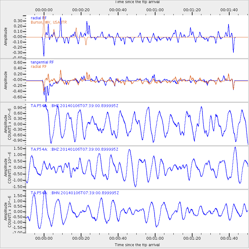
P54A Burton, WV, USA - Earthquake Result Viewer
*The percent match for this event was below the threshold and hence no stack was calculated.
| Earthquake location: |
Kuril Islands |
| Earthquake latitude/longitude: |
46.2/152.1 |
| Earthquake time(UTC): |
2014/01/06 (006) 07:27:20 GMT |
| Earthquake Depth: |
100 km |
| Earthquake Magnitude: |
3.5 mb |
| Earthquake Catalog/Contributor: |
ISC/ISC |
|
| Network: |
TA USArray Transportable Network (new EarthScope stations) |
| Station: |
P54A Burton, WV, USA |
| Lat/Lon: |
39.61 N/80.48 W |
| Elevation: |
473 m |
|
| Distance: |
82.5 deg |
| Az: |
38.246 deg |
| Baz: |
326.179 deg |
| Ray Param: |
$rayparam |
*The percent match for this event was below the threshold and hence was not used in the summary stack. |
|
| Radial Match: |
55.66254 % |
| Radial Bump: |
400 |
| Transverse Match: |
75.78084 % |
| Transverse Bump: |
400 |
| SOD ConfigId: |
3390531 |
| Insert Time: |
2019-04-09 21:51:43.201 +0000 |
| GWidth: |
2.5 |
| Max Bumps: |
400 |
| Tol: |
0.001 |
|
Signal To Noise
| Channel | StoN | STA | LTA |
| TA:P54A: :BHZ:20140106T07:39:00.899995Z | 0.27960274 | 2.2543017E-7 | 8.0625165E-7 |
| TA:P54A: :BHN:20140106T07:39:00.899995Z | 2.0562513 | 1.1492476E-6 | 5.589043E-7 |
| TA:P54A: :BHE:20140106T07:39:00.899995Z | 0.62368 | 3.7981823E-7 | 6.089953E-7 |
| Arrivals |
| Ps | |
| PpPs | |
| PsPs/PpSs | |


