You are here: Home > Network List > TM - Thai Seismic Monitoring Network Stations List
> Station MHIT Mueang, MaeHongSon > Earthquake Result Viewer
MHIT Mueang, MaeHongSon - Earthquake Result Viewer
| Earthquake location: |
Tonga Islands |
| Earthquake latitude/longitude: |
-18.1/-174.3 |
| Earthquake time(UTC): |
2024/04/05 (096) 20:32:13 GMT |
| Earthquake Depth: |
119 km |
| Earthquake Magnitude: |
5.6 Mww |
| Earthquake Catalog/Contributor: |
NEIC PDE/us |
|
| Network: |
TM Thai Seismic Monitoring Network |
| Station: |
MHIT Mueang, MaeHongSon |
| Lat/Lon: |
19.31 N/97.96 E |
| Elevation: |
270 m |
|
| Distance: |
93.8 deg |
| Az: |
288.968 deg |
| Baz: |
107.776 deg |
| Ray Param: |
0.04112158 |
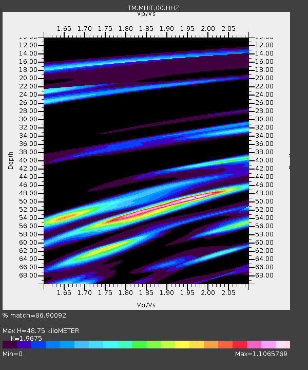
| Estimated Moho Depth: |
48.75 km |
| Estimated Crust Vp/Vs: |
1.97 |
| Assumed Crust Vp: |
6.316 km/s |
| Estimated Crust Vs: |
3.21 km/s |
| Estimated Crust Poisson's Ratio: |
0.33 |
|
| Radial Match: |
86.90092 % |
| Radial Bump: |
300 |
| Transverse Match: |
87.16483 % |
| Transverse Bump: |
246 |
| SOD ConfigId: |
34025071 |
| Insert Time: |
2024-04-19 20:52:17.998 +0000 |
| GWidth: |
2.5 |
| Max Bumps: |
400 |
| Tol: |
0.001 |
|

Signal To Noise
| Channel | StoN | STA | LTA |
| TM:MHIT:00:HHZ:20240405T20:44:45.950007Z | 1.5385993 | 1.6638447E-8 | 1.0814023E-8 |
| TM:MHIT:00:HHN:20240405T20:44:45.950007Z | 1.531876 | 1.7071681E-8 | 1.1144297E-8 |
| TM:MHIT:00:HHE:20240405T20:44:45.950007Z | 1.4493638 | 2.5986035E-8 | 1.7929269E-8 |
| Arrivals |
| Ps | 7.6 SECOND |
| PpPs | 23 SECOND |
| PsPs/PpSs | 30 SECOND |


