You are here: Home > Network List > AK - Alaska Regional Network Stations List
> Station BAE Barry Arm East, AK, USA > Earthquake Result Viewer
BAE Barry Arm East, AK, USA - Earthquake Result Viewer
| Earthquake location: |
Northern Molucca Sea |
| Earthquake latitude/longitude: |
2.7/127.1 |
| Earthquake time(UTC): |
2024/04/09 (100) 09:48:01 GMT |
| Earthquake Depth: |
35 km |
| Earthquake Magnitude: |
6.6 mww |
| Earthquake Catalog/Contributor: |
NEIC PDE/us |
|
| Network: |
AK Alaska Regional Network |
| Station: |
BAE Barry Arm East, AK, USA |
| Lat/Lon: |
61.13 N/148.12 W |
| Elevation: |
578 m |
|
| Distance: |
85.1 deg |
| Az: |
29.015 deg |
| Baz: |
266.743 deg |
| Ray Param: |
0.044953965 |
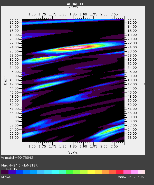
| Estimated Moho Depth: |
24.0 km |
| Estimated Crust Vp/Vs: |
1.85 |
| Assumed Crust Vp: |
6.566 km/s |
| Estimated Crust Vs: |
3.549 km/s |
| Estimated Crust Poisson's Ratio: |
0.29 |
|
| Radial Match: |
90.78043 % |
| Radial Bump: |
400 |
| Transverse Match: |
86.06402 % |
| Transverse Bump: |
400 |
| SOD ConfigId: |
34025071 |
| Insert Time: |
2024-04-23 09:50:56.531 +0000 |
| GWidth: |
2.5 |
| Max Bumps: |
400 |
| Tol: |
0.001 |
|

Signal To Noise
| Channel | StoN | STA | LTA |
| AK:BAE: :BHZ:20240409T10:00:02.867988Z | 6.003048 | 1.0036572E-6 | 1.6719126E-7 |
| AK:BAE: :BHN:20240409T10:00:02.867988Z | 0.90893286 | 1.8973469E-7 | 2.0874445E-7 |
| AK:BAE: :BHE:20240409T10:00:02.867988Z | 2.809272 | 4.47994E-7 | 1.5946978E-7 |
| Arrivals |
| Ps | 3.2 SECOND |
| PpPs | 10 SECOND |
| PsPs/PpSs | 13 SECOND |


