You are here: Home > Network List > AK - Alaska Regional Network Stations List
> Station H20K Anotleneega Mountain, AK, USA > Earthquake Result Viewer
H20K Anotleneega Mountain, AK, USA - Earthquake Result Viewer
| Earthquake location: |
Northern Molucca Sea |
| Earthquake latitude/longitude: |
2.7/127.1 |
| Earthquake time(UTC): |
2024/04/09 (100) 09:48:01 GMT |
| Earthquake Depth: |
35 km |
| Earthquake Magnitude: |
6.6 mww |
| Earthquake Catalog/Contributor: |
NEIC PDE/us |
|
| Network: |
AK Alaska Regional Network |
| Station: |
H20K Anotleneega Mountain, AK, USA |
| Lat/Lon: |
65.49 N/154.88 W |
| Elevation: |
514 m |
|
| Distance: |
82.6 deg |
| Az: |
24.299 deg |
| Baz: |
260.202 deg |
| Ray Param: |
0.046747923 |
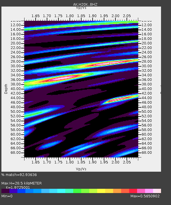
| Estimated Moho Depth: |
28.5 km |
| Estimated Crust Vp/Vs: |
1.97 |
| Assumed Crust Vp: |
6.566 km/s |
| Estimated Crust Vs: |
3.329 km/s |
| Estimated Crust Poisson's Ratio: |
0.33 |
|
| Radial Match: |
92.93636 % |
| Radial Bump: |
400 |
| Transverse Match: |
83.927734 % |
| Transverse Bump: |
400 |
| SOD ConfigId: |
34025071 |
| Insert Time: |
2024-04-23 09:52:13.013 +0000 |
| GWidth: |
2.5 |
| Max Bumps: |
400 |
| Tol: |
0.001 |
|

Signal To Noise
| Channel | StoN | STA | LTA |
| AK:H20K: :BHZ:20240409T09:59:49.979988Z | 10.719188 | 1.3086907E-6 | 1.2208861E-7 |
| AK:H20K: :BHN:20240409T09:59:49.979988Z | 2.0561676 | 1.418696E-7 | 6.89971E-8 |
| AK:H20K: :BHE:20240409T09:59:49.979988Z | 4.0906644 | 4.4380656E-7 | 1.08492536E-7 |
| Arrivals |
| Ps | 4.3 SECOND |
| PpPs | 13 SECOND |
| PsPs/PpSs | 17 SECOND |


