You are here: Home > Network List > AK - Alaska Regional Network Stations List
> Station K15K Wolf Creek Mountain, AK, USA > Earthquake Result Viewer
K15K Wolf Creek Mountain, AK, USA - Earthquake Result Viewer
| Earthquake location: |
Northern Molucca Sea |
| Earthquake latitude/longitude: |
2.7/127.1 |
| Earthquake time(UTC): |
2024/04/09 (100) 09:48:01 GMT |
| Earthquake Depth: |
35 km |
| Earthquake Magnitude: |
6.6 mww |
| Earthquake Catalog/Contributor: |
NEIC PDE/us |
|
| Network: |
AK Alaska Regional Network |
| Station: |
K15K Wolf Creek Mountain, AK, USA |
| Lat/Lon: |
62.29 N/161.53 W |
| Elevation: |
346 m |
|
| Distance: |
79.0 deg |
| Az: |
26.82 deg |
| Baz: |
254.638 deg |
| Ray Param: |
0.049209855 |
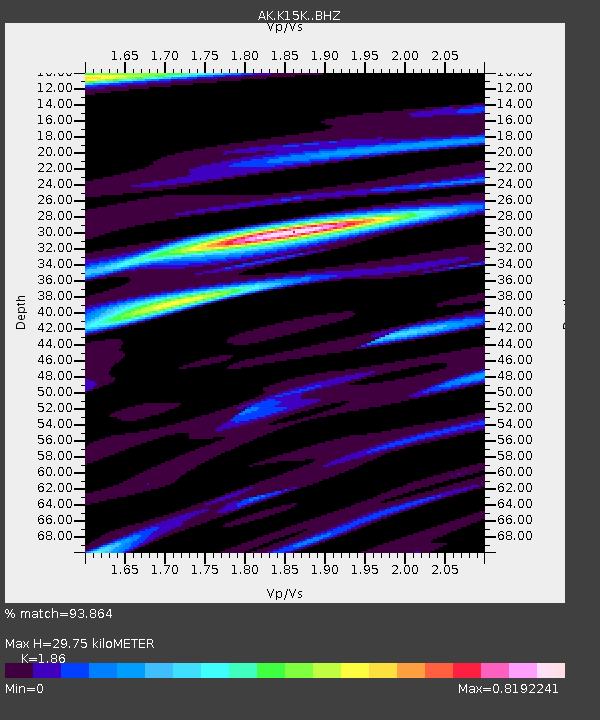
| Estimated Moho Depth: |
29.75 km |
| Estimated Crust Vp/Vs: |
1.86 |
| Assumed Crust Vp: |
6.276 km/s |
| Estimated Crust Vs: |
3.374 km/s |
| Estimated Crust Poisson's Ratio: |
0.30 |
|
| Radial Match: |
93.864 % |
| Radial Bump: |
400 |
| Transverse Match: |
86.20391 % |
| Transverse Bump: |
387 |
| SOD ConfigId: |
34025071 |
| Insert Time: |
2024-04-23 09:52:37.917 +0000 |
| GWidth: |
2.5 |
| Max Bumps: |
400 |
| Tol: |
0.001 |
|

Signal To Noise
| Channel | StoN | STA | LTA |
| AK:K15K: :BHZ:20240409T09:59:31.000007Z | 7.3469334 | 1.1257126E-6 | 1.532221E-7 |
| AK:K15K: :BHN:20240409T09:59:31.000007Z | 0.9115067 | 1.508029E-7 | 1.6544354E-7 |
| AK:K15K: :BHE:20240409T09:59:31.000007Z | 2.8548915 | 3.466622E-7 | 1.2142746E-7 |
| Arrivals |
| Ps | 4.2 SECOND |
| PpPs | 13 SECOND |
| PsPs/PpSs | 17 SECOND |


