You are here: Home > Network List > CI - Caltech Regional Seismic Network Stations List
> Station SLA SLA, Trona, CA, USA > Earthquake Result Viewer
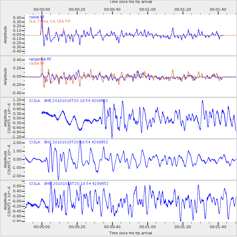
SLA SLA, Trona, CA, USA - Earthquake Result Viewer
*The percent match for this event was below the threshold and hence no stack was calculated.
| Earthquake location: |
Tonga Islands |
| Earthquake latitude/longitude: |
-20.4/-173.8 |
| Earthquake time(UTC): |
2010/10/16 (289) 20:08:30 GMT |
| Earthquake Depth: |
8.0 km |
| Earthquake Magnitude: |
6.1 MB, 5.9 MS, 5.9 MW, 5.8 MW |
| Earthquake Catalog/Contributor: |
WHDF/NEIC |
|
| Network: |
CI Caltech Regional Seismic Network |
| Station: |
SLA SLA, Trona, CA, USA |
| Lat/Lon: |
35.89 N/117.28 W |
| Elevation: |
1174 m |
|
| Distance: |
77.5 deg |
| Az: |
43.963 deg |
| Baz: |
233.31 deg |
| Ray Param: |
$rayparam |
*The percent match for this event was below the threshold and hence was not used in the summary stack. |
|
| Radial Match: |
71.264854 % |
| Radial Bump: |
400 |
| Transverse Match: |
74.64032 % |
| Transverse Bump: |
400 |
| SOD ConfigId: |
339645 |
| Insert Time: |
2011-02-17 08:18:35.491 +0000 |
| GWidth: |
2.5 |
| Max Bumps: |
400 |
| Tol: |
0.001 |
|
Signal To Noise
| Channel | StoN | STA | LTA |
| CI:SLA: :BHZ:20101016T20:19:54.429985Z | 3.7054088 | 6.2055875E-7 | 1.6747377E-7 |
| CI:SLA: :BHN:20101016T20:19:54.429985Z | 1.7209657 | 2.1652971E-7 | 1.2581873E-7 |
| CI:SLA: :BHE:20101016T20:19:54.429985Z | 0.5866014 | 1.9752385E-7 | 3.3672583E-7 |
| Arrivals |
| Ps | |
| PpPs | |
| PsPs/PpSs | |


