You are here: Home > Network List > AV - Alaska Volcano Observatory Stations List
> Station ACH Angle Creek Headwaters, Katmai, Alaska > Earthquake Result Viewer
ACH Angle Creek Headwaters, Katmai, Alaska - Earthquake Result Viewer
| Earthquake location: |
Northern Molucca Sea |
| Earthquake latitude/longitude: |
2.7/127.1 |
| Earthquake time(UTC): |
2024/04/09 (100) 09:48:01 GMT |
| Earthquake Depth: |
35 km |
| Earthquake Magnitude: |
6.6 mww |
| Earthquake Catalog/Contributor: |
NEIC PDE/us |
|
| Network: |
AV Alaska Volcano Observatory |
| Station: |
ACH Angle Creek Headwaters, Katmai, Alaska |
| Lat/Lon: |
58.21 N/155.33 W |
| Elevation: |
960 m |
|
| Distance: |
81.2 deg |
| Az: |
31.546 deg |
| Baz: |
260.834 deg |
| Ray Param: |
0.04773766 |
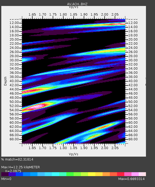
| Estimated Moho Depth: |
12.25 km |
| Estimated Crust Vp/Vs: |
2.10 |
| Assumed Crust Vp: |
6.438 km/s |
| Estimated Crust Vs: |
3.069 km/s |
| Estimated Crust Poisson's Ratio: |
0.35 |
|
| Radial Match: |
82.31814 % |
| Radial Bump: |
400 |
| Transverse Match: |
81.63581 % |
| Transverse Bump: |
400 |
| SOD ConfigId: |
34025071 |
| Insert Time: |
2024-04-23 09:55:15.536 +0000 |
| GWidth: |
2.5 |
| Max Bumps: |
400 |
| Tol: |
0.001 |
|

Signal To Noise
| Channel | StoN | STA | LTA |
| AV:ACH: :BHZ:20240409T09:59:42.568Z | 5.8481936 | 1.145294E-6 | 1.9583723E-7 |
| AV:ACH: :BHN:20240409T09:59:42.568Z | 3.2655385 | 5.301142E-7 | 1.6233592E-7 |
| AV:ACH: :BHE:20240409T09:59:42.568Z | 3.7659173 | 9.807069E-7 | 2.6041644E-7 |
| Arrivals |
| Ps | 2.1 SECOND |
| PpPs | 5.8 SECOND |
| PsPs/PpSs | 7.9 SECOND |


