You are here: Home > Network List > AV - Alaska Volcano Observatory Stations List
> Station KAWH Katmai, Alaska > Earthquake Result Viewer
KAWH Katmai, Alaska - Earthquake Result Viewer
| Earthquake location: |
Northern Molucca Sea |
| Earthquake latitude/longitude: |
2.7/127.1 |
| Earthquake time(UTC): |
2024/04/09 (100) 09:48:01 GMT |
| Earthquake Depth: |
35 km |
| Earthquake Magnitude: |
6.6 mww |
| Earthquake Catalog/Contributor: |
NEIC PDE/us |
|
| Network: |
AV Alaska Volcano Observatory |
| Station: |
KAWH Katmai, Alaska |
| Lat/Lon: |
58.38 N/154.80 W |
| Elevation: |
777 m |
|
| Distance: |
81.5 deg |
| Az: |
31.416 deg |
| Baz: |
261.261 deg |
| Ray Param: |
0.04752616 |
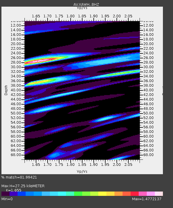
| Estimated Moho Depth: |
27.25 km |
| Estimated Crust Vp/Vs: |
1.65 |
| Assumed Crust Vp: |
6.438 km/s |
| Estimated Crust Vs: |
3.89 km/s |
| Estimated Crust Poisson's Ratio: |
0.21 |
|
| Radial Match: |
81.99421 % |
| Radial Bump: |
400 |
| Transverse Match: |
75.802086 % |
| Transverse Bump: |
400 |
| SOD ConfigId: |
34025071 |
| Insert Time: |
2024-04-23 09:56:12.684 +0000 |
| GWidth: |
2.5 |
| Max Bumps: |
400 |
| Tol: |
0.001 |
|

Signal To Noise
| Channel | StoN | STA | LTA |
| AV:KAWH: :BHZ:20240409T09:59:44.159004Z | 3.9112825 | 1.1597763E-6 | 2.965207E-7 |
| AV:KAWH: :BHN:20240409T09:59:44.159004Z | 0.8581463 | 2.095884E-7 | 2.442339E-7 |
| AV:KAWH: :BHE:20240409T09:59:44.159004Z | 2.2693224 | 5.957979E-7 | 2.625444E-7 |
| Arrivals |
| Ps | 2.9 SECOND |
| PpPs | 11 SECOND |
| PsPs/PpSs | 14 SECOND |


