You are here: Home > Network List > TA - USArray Transportable Network (new EarthScope stations) Stations List
> Station T25A Trinidad, CO, USA > Earthquake Result Viewer
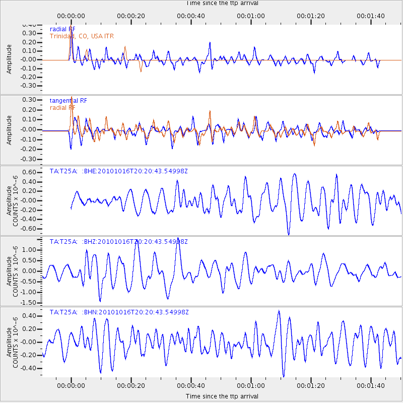
T25A Trinidad, CO, USA - Earthquake Result Viewer
*The percent match for this event was below the threshold and hence no stack was calculated.
| Earthquake location: |
Tonga Islands |
| Earthquake latitude/longitude: |
-20.4/-173.8 |
| Earthquake time(UTC): |
2010/10/16 (289) 20:08:30 GMT |
| Earthquake Depth: |
8.0 km |
| Earthquake Magnitude: |
6.1 MB, 5.9 MS, 5.9 MW, 5.8 MW |
| Earthquake Catalog/Contributor: |
WHDF/NEIC |
|
| Network: |
TA USArray Transportable Network (new EarthScope stations) |
| Station: |
T25A Trinidad, CO, USA |
| Lat/Lon: |
37.14 N/104.41 W |
| Elevation: |
2017 m |
|
| Distance: |
86.9 deg |
| Az: |
48.532 deg |
| Baz: |
241.583 deg |
| Ray Param: |
$rayparam |
*The percent match for this event was below the threshold and hence was not used in the summary stack. |
|
| Radial Match: |
71.61842 % |
| Radial Bump: |
400 |
| Transverse Match: |
69.143135 % |
| Transverse Bump: |
400 |
| SOD ConfigId: |
339645 |
| Insert Time: |
2011-02-17 08:24:33.487 +0000 |
| GWidth: |
2.5 |
| Max Bumps: |
400 |
| Tol: |
0.001 |
|
Signal To Noise
| Channel | StoN | STA | LTA |
| TA:T25A: :BHZ:20101016T20:20:43.54998Z | 2.1707976 | 2.9141384E-7 | 1.3424275E-7 |
| TA:T25A: :BHN:20101016T20:20:43.54998Z | 1.0052154 | 1.3352306E-7 | 1.328303E-7 |
| TA:T25A: :BHE:20101016T20:20:43.54998Z | 1.5847584 | 1.9176301E-7 | 1.2100456E-7 |
| Arrivals |
| Ps | |
| PpPs | |
| PsPs/PpSs | |


