You are here: Home > Network List > TA - USArray Transportable Network (new EarthScope stations) Stations List
> Station T26A Comanche National Grassland Park, Kim, CO, USA > Earthquake Result Viewer
T26A Comanche National Grassland Park, Kim, CO, USA - Earthquake Result Viewer
| Earthquake location: |
Tonga Islands |
| Earthquake latitude/longitude: |
-20.4/-173.8 |
| Earthquake time(UTC): |
2010/10/16 (289) 20:08:30 GMT |
| Earthquake Depth: |
8.0 km |
| Earthquake Magnitude: |
6.1 MB, 5.9 MS, 5.9 MW, 5.8 MW |
| Earthquake Catalog/Contributor: |
WHDF/NEIC |
|
| Network: |
TA USArray Transportable Network (new EarthScope stations) |
| Station: |
T26A Comanche National Grassland Park, Kim, CO, USA |
| Lat/Lon: |
37.17 N/103.59 W |
| Elevation: |
1830 m |
|
| Distance: |
87.4 deg |
| Az: |
48.809 deg |
| Baz: |
242.089 deg |
| Ray Param: |
0.043320812 |
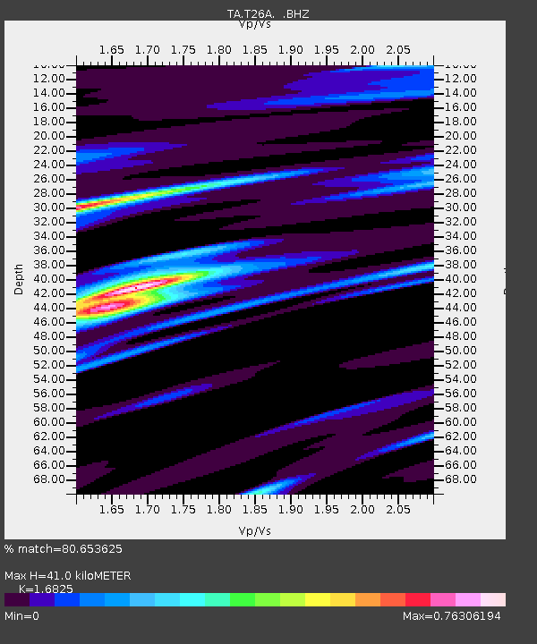
| Estimated Moho Depth: |
41.0 km |
| Estimated Crust Vp/Vs: |
1.68 |
| Assumed Crust Vp: |
6.306 km/s |
| Estimated Crust Vs: |
3.748 km/s |
| Estimated Crust Poisson's Ratio: |
0.23 |
|
| Radial Match: |
80.653625 % |
| Radial Bump: |
366 |
| Transverse Match: |
34.92823 % |
| Transverse Bump: |
331 |
| SOD ConfigId: |
339645 |
| Insert Time: |
2011-02-17 08:25:02.098 +0000 |
| GWidth: |
2.5 |
| Max Bumps: |
400 |
| Tol: |
0.001 |
|
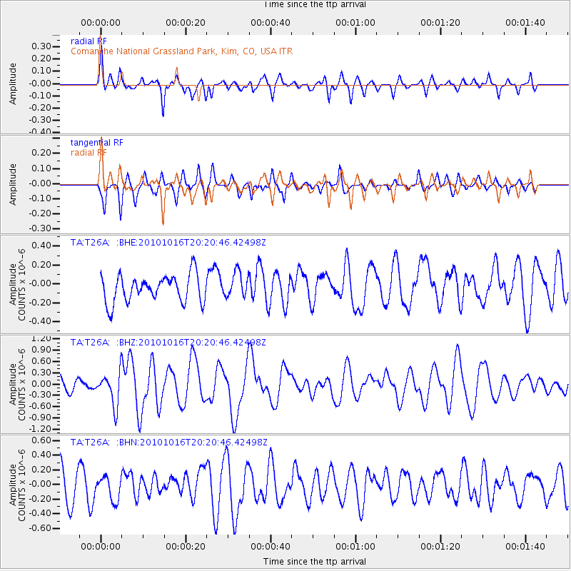
Signal To Noise
| Channel | StoN | STA | LTA |
| TA:T26A: :BHZ:20101016T20:20:46.42498Z | 3.2878866 | 4.5103448E-7 | 1.3718068E-7 |
| TA:T26A: :BHN:20101016T20:20:46.42498Z | 0.51827186 | 1.6568715E-7 | 3.196916E-7 |
| TA:T26A: :BHE:20101016T20:20:46.42498Z | 0.95056695 | 1.3665051E-7 | 1.4375685E-7 |
| Arrivals |
| Ps | 4.5 SECOND |
| PpPs | 17 SECOND |
| PsPs/PpSs | 22 SECOND |


