You are here: Home > Network List > TA - USArray Transportable Network (new EarthScope stations) Stations List
> Station 532A Rocksprings, TX, USA > Earthquake Result Viewer
532A Rocksprings, TX, USA - Earthquake Result Viewer
| Earthquake location: |
Tonga Islands |
| Earthquake latitude/longitude: |
-20.4/-173.8 |
| Earthquake time(UTC): |
2010/10/16 (289) 20:08:30 GMT |
| Earthquake Depth: |
8.0 km |
| Earthquake Magnitude: |
6.1 MB, 5.9 MS, 5.9 MW, 5.8 MW |
| Earthquake Catalog/Contributor: |
WHDF/NEIC |
|
| Network: |
TA USArray Transportable Network (new EarthScope stations) |
| Station: |
532A Rocksprings, TX, USA |
| Lat/Lon: |
30.13 N/99.90 W |
| Elevation: |
703 m |
|
| Distance: |
87.0 deg |
| Az: |
56.478 deg |
| Baz: |
244.497 deg |
| Ray Param: |
0.043614667 |
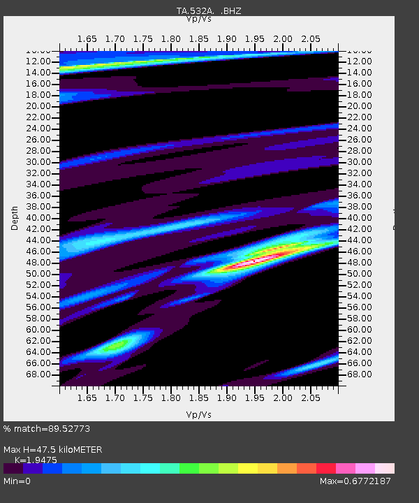
| Estimated Moho Depth: |
47.5 km |
| Estimated Crust Vp/Vs: |
1.95 |
| Assumed Crust Vp: |
6.498 km/s |
| Estimated Crust Vs: |
3.336 km/s |
| Estimated Crust Poisson's Ratio: |
0.32 |
|
| Radial Match: |
89.52773 % |
| Radial Bump: |
278 |
| Transverse Match: |
73.07376 % |
| Transverse Bump: |
290 |
| SOD ConfigId: |
339645 |
| Insert Time: |
2011-02-17 08:27:12.259 +0000 |
| GWidth: |
2.5 |
| Max Bumps: |
400 |
| Tol: |
0.001 |
|
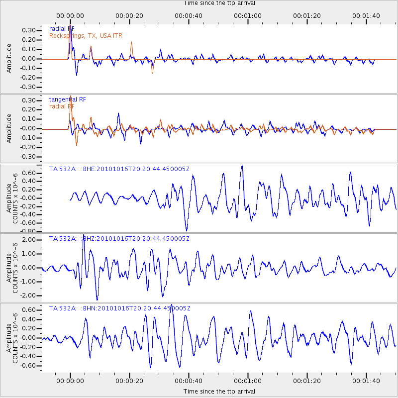
Signal To Noise
| Channel | StoN | STA | LTA |
| TA:532A: :BHZ:20101016T20:20:44.450005Z | 7.6377726 | 8.6093945E-7 | 1.12721274E-7 |
| TA:532A: :BHN:20101016T20:20:44.450005Z | 0.9557491 | 1.1097002E-7 | 1.161079E-7 |
| TA:532A: :BHE:20101016T20:20:44.450005Z | 2.3833764 | 1.820283E-7 | 7.637413E-8 |
| Arrivals |
| Ps | 7.1 SECOND |
| PpPs | 21 SECOND |
| PsPs/PpSs | 28 SECOND |


