You are here: Home > Network List > TA - USArray Transportable Network (new EarthScope stations) Stations List
> Station X30A Coker Ranch, Turkey, TX, USA > Earthquake Result Viewer
X30A Coker Ranch, Turkey, TX, USA - Earthquake Result Viewer
| Earthquake location: |
Tonga Islands |
| Earthquake latitude/longitude: |
-20.4/-173.8 |
| Earthquake time(UTC): |
2010/10/16 (289) 20:08:30 GMT |
| Earthquake Depth: |
8.0 km |
| Earthquake Magnitude: |
6.1 MB, 5.9 MS, 5.9 MW, 5.8 MW |
| Earthquake Catalog/Contributor: |
WHDF/NEIC |
|
| Network: |
TA USArray Transportable Network (new EarthScope stations) |
| Station: |
X30A Coker Ranch, Turkey, TX, USA |
| Lat/Lon: |
34.45 N/100.87 W |
| Elevation: |
698 m |
|
| Distance: |
88.2 deg |
| Az: |
52.241 deg |
| Baz: |
243.804 deg |
| Ray Param: |
0.042781822 |
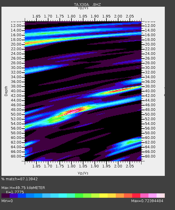
| Estimated Moho Depth: |
49.75 km |
| Estimated Crust Vp/Vs: |
1.78 |
| Assumed Crust Vp: |
6.426 km/s |
| Estimated Crust Vs: |
3.615 km/s |
| Estimated Crust Poisson's Ratio: |
0.27 |
|
| Radial Match: |
87.13942 % |
| Radial Bump: |
319 |
| Transverse Match: |
67.13488 % |
| Transverse Bump: |
343 |
| SOD ConfigId: |
339645 |
| Insert Time: |
2011-02-17 08:28:07.916 +0000 |
| GWidth: |
2.5 |
| Max Bumps: |
400 |
| Tol: |
0.001 |
|
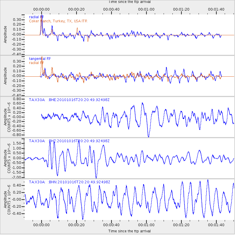
Signal To Noise
| Channel | StoN | STA | LTA |
| TA:X30A: :BHZ:20101016T20:20:49.92498Z | 5.0690923 | 5.6687435E-7 | 1.11829564E-7 |
| TA:X30A: :BHN:20101016T20:20:49.92498Z | 0.54853284 | 1.2729987E-7 | 2.3207336E-7 |
| TA:X30A: :BHE:20101016T20:20:49.92498Z | 2.1735861 | 2.0782343E-7 | 9.561316E-8 |
| Arrivals |
| Ps | 6.2 SECOND |
| PpPs | 21 SECOND |
| PsPs/PpSs | 27 SECOND |


