You are here: Home > Network List > TA - USArray Transportable Network (new EarthScope stations) Stations List
> Station S31A Mullinville, KS, USA > Earthquake Result Viewer
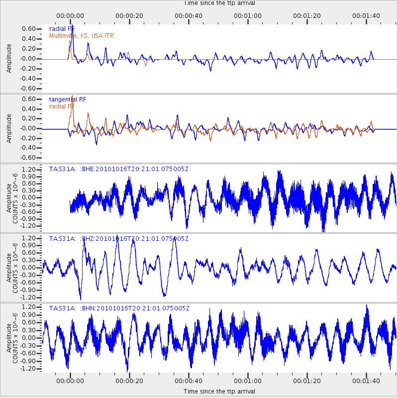
S31A Mullinville, KS, USA - Earthquake Result Viewer
*The percent match for this event was below the threshold and hence no stack was calculated.
| Earthquake location: |
Tonga Islands |
| Earthquake latitude/longitude: |
-20.4/-173.8 |
| Earthquake time(UTC): |
2010/10/16 (289) 20:08:30 GMT |
| Earthquake Depth: |
8.0 km |
| Earthquake Magnitude: |
6.1 MB, 5.9 MS, 5.9 MW, 5.8 MW |
| Earthquake Catalog/Contributor: |
WHDF/NEIC |
|
| Network: |
TA USArray Transportable Network (new EarthScope stations) |
| Station: |
S31A Mullinville, KS, USA |
| Lat/Lon: |
37.62 N/99.48 W |
| Elevation: |
700 m |
|
| Distance: |
90.6 deg |
| Az: |
49.881 deg |
| Baz: |
244.593 deg |
| Ray Param: |
$rayparam |
*The percent match for this event was below the threshold and hence was not used in the summary stack. |
|
| Radial Match: |
79.52463 % |
| Radial Bump: |
400 |
| Transverse Match: |
48.855835 % |
| Transverse Bump: |
400 |
| SOD ConfigId: |
339645 |
| Insert Time: |
2011-02-17 08:29:30.802 +0000 |
| GWidth: |
2.5 |
| Max Bumps: |
400 |
| Tol: |
0.001 |
|
Signal To Noise
| Channel | StoN | STA | LTA |
| TA:S31A: :BHZ:20101016T20:21:01.075005Z | 3.515695 | 5.5585014E-7 | 1.5810534E-7 |
| TA:S31A: :BHN:20101016T20:21:01.075005Z | 1.3213764 | 4.5521148E-7 | 3.4449795E-7 |
| TA:S31A: :BHE:20101016T20:21:01.075005Z | 1.1368917 | 3.8424216E-7 | 3.3797602E-7 |
| Arrivals |
| Ps | |
| PpPs | |
| PsPs/PpSs | |


