You are here: Home > Network List > TA - USArray Transportable Network (new EarthScope stations) Stations List
> Station H28A Mission Ridge, SD, USA > Earthquake Result Viewer
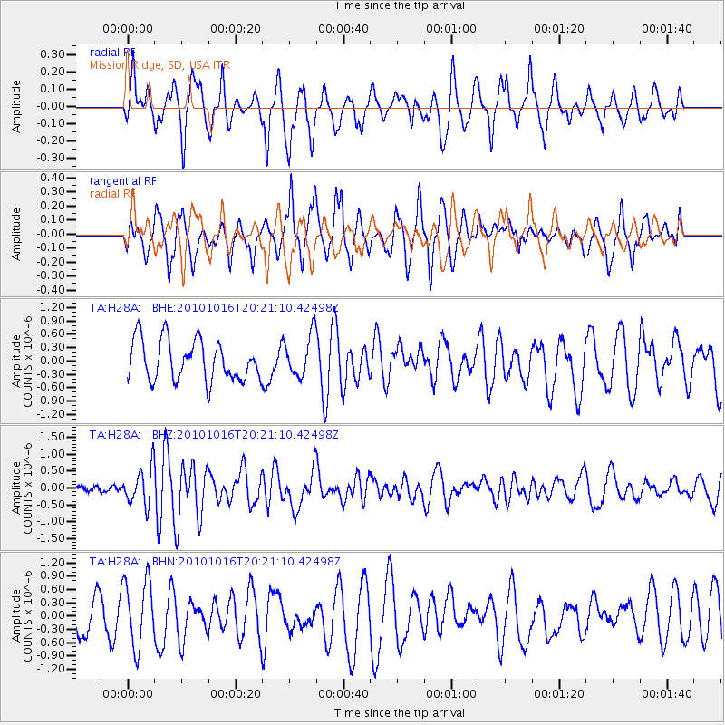
H28A Mission Ridge, SD, USA - Earthquake Result Viewer
*The percent match for this event was below the threshold and hence no stack was calculated.
| Earthquake location: |
Tonga Islands |
| Earthquake latitude/longitude: |
-20.4/-173.8 |
| Earthquake time(UTC): |
2010/10/16 (289) 20:08:30 GMT |
| Earthquake Depth: |
8.0 km |
| Earthquake Magnitude: |
6.1 MB, 5.9 MS, 5.9 MW, 5.8 MW |
| Earthquake Catalog/Contributor: |
WHDF/NEIC |
|
| Network: |
TA USArray Transportable Network (new EarthScope stations) |
| Station: |
H28A Mission Ridge, SD, USA |
| Lat/Lon: |
44.68 N/101.02 W |
| Elevation: |
642 m |
|
| Distance: |
92.6 deg |
| Az: |
43.028 deg |
| Baz: |
243.774 deg |
| Ray Param: |
$rayparam |
*The percent match for this event was below the threshold and hence was not used in the summary stack. |
|
| Radial Match: |
58.896633 % |
| Radial Bump: |
348 |
| Transverse Match: |
59.465782 % |
| Transverse Bump: |
387 |
| SOD ConfigId: |
339645 |
| Insert Time: |
2011-02-17 08:30:38.794 +0000 |
| GWidth: |
2.5 |
| Max Bumps: |
400 |
| Tol: |
0.001 |
|
Signal To Noise
| Channel | StoN | STA | LTA |
| TA:H28A: :BHZ:20101016T20:21:10.42498Z | 2.2350633 | 5.5204157E-7 | 2.4699148E-7 |
| TA:H28A: :BHN:20101016T20:21:10.42498Z | 1.3828087 | 7.5541595E-7 | 5.46291E-7 |
| TA:H28A: :BHE:20101016T20:21:10.42498Z | 1.0645429 | 4.782045E-7 | 4.4921111E-7 |
| Arrivals |
| Ps | |
| PpPs | |
| PsPs/PpSs | |


