You are here: Home > Network List > TA - USArray Transportable Network (new EarthScope stations) Stations List
> Station I28A Midland, SD, USA > Earthquake Result Viewer
I28A Midland, SD, USA - Earthquake Result Viewer
| Earthquake location: |
Tonga Islands |
| Earthquake latitude/longitude: |
-20.4/-173.8 |
| Earthquake time(UTC): |
2010/10/16 (289) 20:08:30 GMT |
| Earthquake Depth: |
8.0 km |
| Earthquake Magnitude: |
6.1 MB, 5.9 MS, 5.9 MW, 5.8 MW |
| Earthquake Catalog/Contributor: |
WHDF/NEIC |
|
| Network: |
TA USArray Transportable Network (new EarthScope stations) |
| Station: |
I28A Midland, SD, USA |
| Lat/Lon: |
44.00 N/101.17 W |
| Elevation: |
655 m |
|
| Distance: |
92.2 deg |
| Az: |
43.586 deg |
| Baz: |
243.647 deg |
| Ray Param: |
0.04149415 |
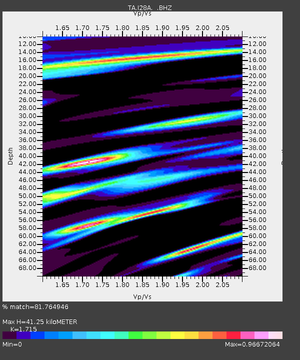
| Estimated Moho Depth: |
41.25 km |
| Estimated Crust Vp/Vs: |
1.72 |
| Assumed Crust Vp: |
6.483 km/s |
| Estimated Crust Vs: |
3.78 km/s |
| Estimated Crust Poisson's Ratio: |
0.24 |
|
| Radial Match: |
81.764946 % |
| Radial Bump: |
378 |
| Transverse Match: |
41.916763 % |
| Transverse Bump: |
354 |
| SOD ConfigId: |
339645 |
| Insert Time: |
2011-02-17 08:30:48.911 +0000 |
| GWidth: |
2.5 |
| Max Bumps: |
400 |
| Tol: |
0.001 |
|
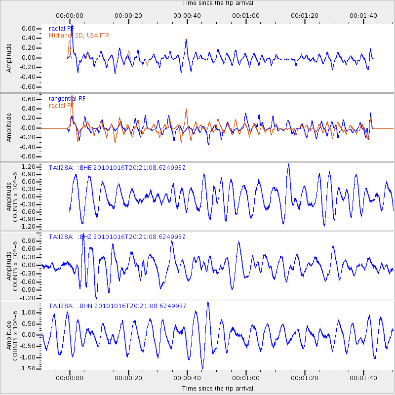
Signal To Noise
| Channel | StoN | STA | LTA |
| TA:I28A: :BHZ:20101016T20:21:08.624993Z | 1.5881946 | 4.3869213E-7 | 2.7622062E-7 |
| TA:I28A: :BHN:20101016T20:21:08.624993Z | 1.546666 | 6.0600087E-7 | 3.9181108E-7 |
| TA:I28A: :BHE:20101016T20:21:08.624993Z | 0.32888448 | 1.4979092E-7 | 4.5545144E-7 |
| Arrivals |
| Ps | 4.6 SECOND |
| PpPs | 17 SECOND |
| PsPs/PpSs | 22 SECOND |


