You are here: Home > Network List > TA - USArray Transportable Network (new EarthScope stations) Stations List
> Station A26A Wade Farm, Kenmare, ND, USA > Earthquake Result Viewer
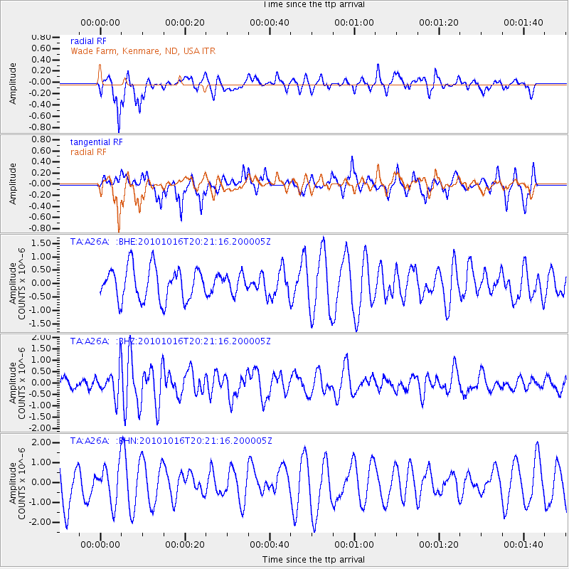
A26A Wade Farm, Kenmare, ND, USA - Earthquake Result Viewer
*The percent match for this event was below the threshold and hence no stack was calculated.
| Earthquake location: |
Tonga Islands |
| Earthquake latitude/longitude: |
-20.4/-173.8 |
| Earthquake time(UTC): |
2010/10/16 (289) 20:08:30 GMT |
| Earthquake Depth: |
8.0 km |
| Earthquake Magnitude: |
6.1 MB, 5.9 MS, 5.9 MW, 5.8 MW |
| Earthquake Catalog/Contributor: |
WHDF/NEIC |
|
| Network: |
TA USArray Transportable Network (new EarthScope stations) |
| Station: |
A26A Wade Farm, Kenmare, ND, USA |
| Lat/Lon: |
48.90 N/102.04 W |
| Elevation: |
570 m |
|
| Distance: |
93.9 deg |
| Az: |
38.929 deg |
| Baz: |
243.265 deg |
| Ray Param: |
$rayparam |
*The percent match for this event was below the threshold and hence was not used in the summary stack. |
|
| Radial Match: |
74.91991 % |
| Radial Bump: |
398 |
| Transverse Match: |
48.864292 % |
| Transverse Bump: |
283 |
| SOD ConfigId: |
339645 |
| Insert Time: |
2011-02-17 08:32:01.178 +0000 |
| GWidth: |
2.5 |
| Max Bumps: |
400 |
| Tol: |
0.001 |
|
Signal To Noise
| Channel | StoN | STA | LTA |
| TA:A26A: :BHZ:20101016T20:21:16.200005Z | 3.1533964 | 6.2804696E-7 | 1.9916526E-7 |
| TA:A26A: :BHN:20101016T20:21:16.200005Z | 1.0415524 | 9.56087E-7 | 9.1794413E-7 |
| TA:A26A: :BHE:20101016T20:21:16.200005Z | 0.553387 | 3.3891223E-7 | 6.1243264E-7 |
| Arrivals |
| Ps | |
| PpPs | |
| PsPs/PpSs | |


