You are here: Home > Network List > TA - USArray Transportable Network (new EarthScope stations) Stations List
> Station J26A Sides Ranch, Smithwick, SD, USA > Earthquake Result Viewer
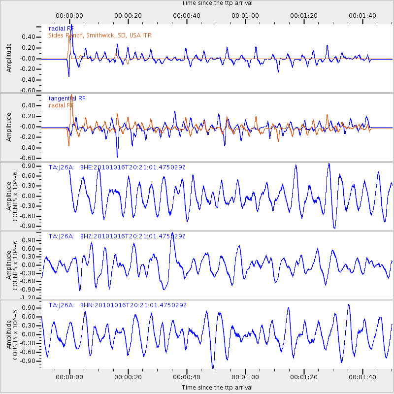
J26A Sides Ranch, Smithwick, SD, USA - Earthquake Result Viewer
*The percent match for this event was below the threshold and hence no stack was calculated.
| Earthquake location: |
Tonga Islands |
| Earthquake latitude/longitude: |
-20.4/-173.8 |
| Earthquake time(UTC): |
2010/10/16 (289) 20:08:30 GMT |
| Earthquake Depth: |
8.0 km |
| Earthquake Magnitude: |
6.1 MB, 5.9 MS, 5.9 MW, 5.8 MW |
| Earthquake Catalog/Contributor: |
WHDF/NEIC |
|
| Network: |
TA USArray Transportable Network (new EarthScope stations) |
| Station: |
J26A Sides Ranch, Smithwick, SD, USA |
| Lat/Lon: |
43.31 N/103.08 W |
| Elevation: |
993 m |
|
| Distance: |
90.7 deg |
| Az: |
43.57 deg |
| Baz: |
242.336 deg |
| Ray Param: |
$rayparam |
*The percent match for this event was below the threshold and hence was not used in the summary stack. |
|
| Radial Match: |
63.05228 % |
| Radial Bump: |
400 |
| Transverse Match: |
77.76063 % |
| Transverse Bump: |
400 |
| SOD ConfigId: |
339645 |
| Insert Time: |
2011-02-17 08:32:18.805 +0000 |
| GWidth: |
2.5 |
| Max Bumps: |
400 |
| Tol: |
0.001 |
|
Signal To Noise
| Channel | StoN | STA | LTA |
| TA:J26A: :BHZ:20101016T20:21:01.475029Z | 1.3444293 | 3.6203295E-7 | 2.6928376E-7 |
| TA:J26A: :BHN:20101016T20:21:01.475029Z | 0.760015 | 3.2592752E-7 | 4.2884352E-7 |
| TA:J26A: :BHE:20101016T20:21:01.475029Z | 1.1493185 | 4.3050227E-7 | 3.745718E-7 |
| Arrivals |
| Ps | |
| PpPs | |
| PsPs/PpSs | |


