You are here: Home > Network List > TA - USArray Transportable Network (new EarthScope stations) Stations List
> Station E28A Huff, ND, USA > Earthquake Result Viewer
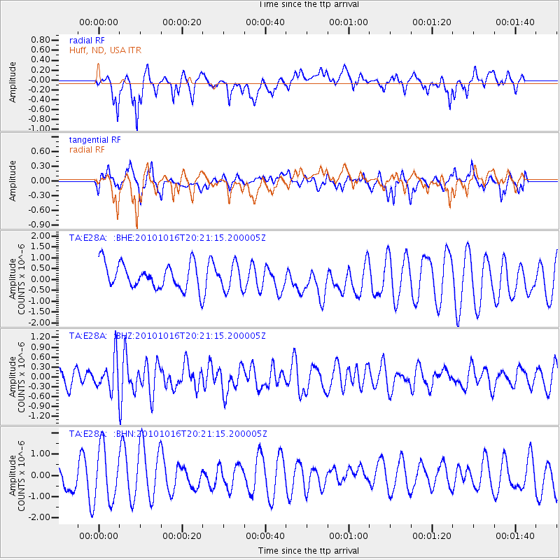
E28A Huff, ND, USA - Earthquake Result Viewer
*The percent match for this event was below the threshold and hence no stack was calculated.
| Earthquake location: |
Tonga Islands |
| Earthquake latitude/longitude: |
-20.4/-173.8 |
| Earthquake time(UTC): |
2010/10/16 (289) 20:08:30 GMT |
| Earthquake Depth: |
8.0 km |
| Earthquake Magnitude: |
6.1 MB, 5.9 MS, 5.9 MW, 5.8 MW |
| Earthquake Catalog/Contributor: |
WHDF/NEIC |
|
| Network: |
TA USArray Transportable Network (new EarthScope stations) |
| Station: |
E28A Huff, ND, USA |
| Lat/Lon: |
46.57 N/100.69 W |
| Elevation: |
579 m |
|
| Distance: |
93.6 deg |
| Az: |
41.419 deg |
| Baz: |
244.095 deg |
| Ray Param: |
$rayparam |
*The percent match for this event was below the threshold and hence was not used in the summary stack. |
|
| Radial Match: |
44.242386 % |
| Radial Bump: |
400 |
| Transverse Match: |
45.41764 % |
| Transverse Bump: |
382 |
| SOD ConfigId: |
339645 |
| Insert Time: |
2011-02-17 08:33:08.371 +0000 |
| GWidth: |
2.5 |
| Max Bumps: |
400 |
| Tol: |
0.001 |
|
Signal To Noise
| Channel | StoN | STA | LTA |
| TA:E28A: :BHZ:20101016T20:21:15.200005Z | 1.9678863 | 5.119011E-7 | 2.6012734E-7 |
| TA:E28A: :BHN:20101016T20:21:15.200005Z | 1.767795 | 1.2371244E-6 | 6.998122E-7 |
| TA:E28A: :BHE:20101016T20:21:15.200005Z | 1.066244 | 6.1151997E-7 | 5.7352725E-7 |
| Arrivals |
| Ps | |
| PpPs | |
| PsPs/PpSs | |


