You are here: Home > Network List > TA - USArray Transportable Network (new EarthScope stations) Stations List
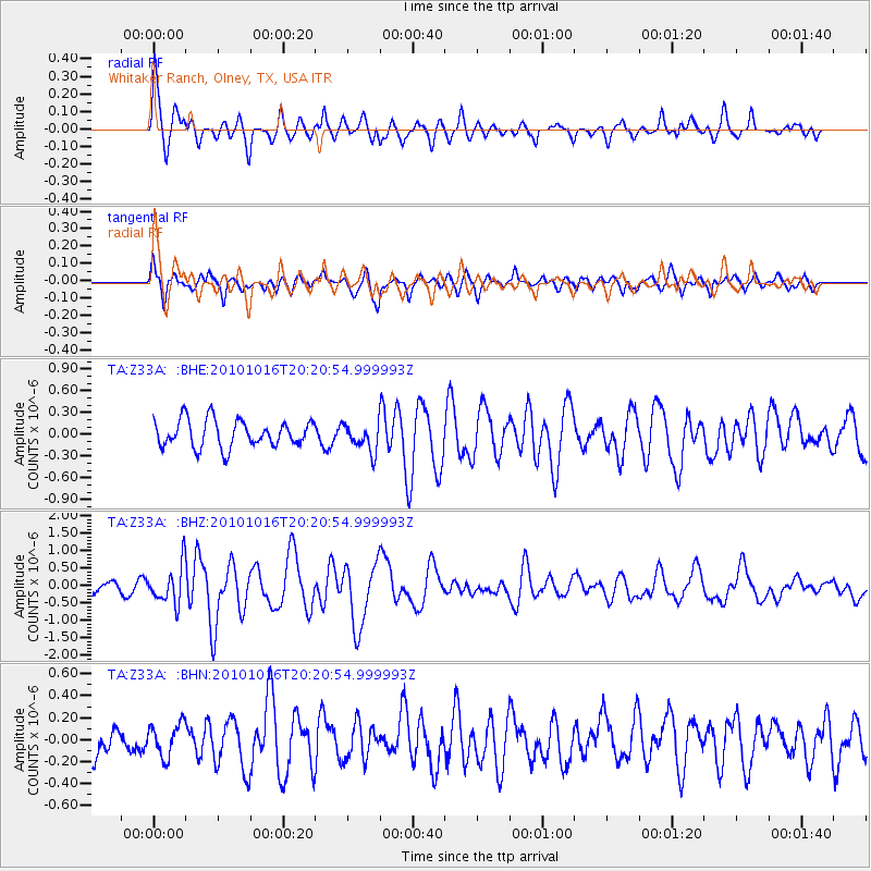
> Station Z33A Whitaker Ranch, Olney, TX, USA > Earthquake Result Viewer
Z33A Whitaker Ranch, Olney, TX, USA - Earthquake Result Viewer
| Earthquake location: |
Tonga Islands |
| Earthquake latitude/longitude: |
-20.4/-173.8 |
| Earthquake time(UTC): |
2010/10/16 (289) 20:08:30 GMT |
| Earthquake Depth: |
8.0 km |
| Earthquake Magnitude: |
6.1 MB, 5.9 MS, 5.9 MW, 5.8 MW |
| Earthquake Catalog/Contributor: |
WHDF/NEIC |
|
| Network: |
TA USArray Transportable Network (new EarthScope stations) |
| Station: |
Z33A Whitaker Ranch, Olney, TX, USA |
| Lat/Lon: |
33.29 N/98.76 W |
| Elevation: |
362 m |
|
| Distance: |
89.3 deg |
| Az: |
54.043 deg |
| Baz: |
245.015 deg |
| Ray Param: |
0.04198067 |
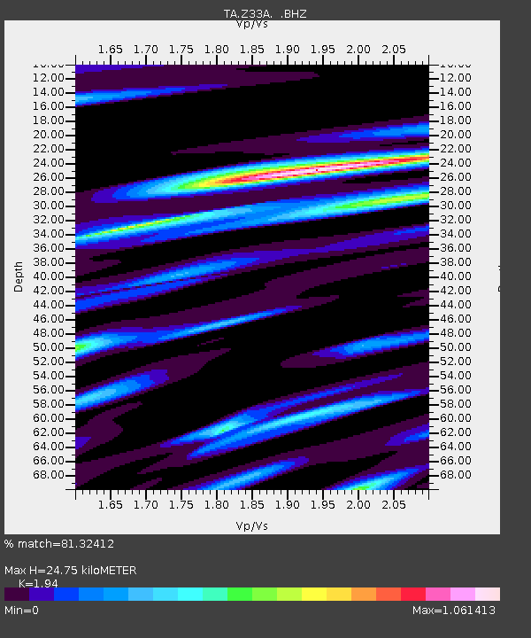
| Estimated Moho Depth: |
24.75 km |
| Estimated Crust Vp/Vs: |
1.94 |
| Assumed Crust Vp: |
6.426 km/s |
| Estimated Crust Vs: |
3.312 km/s |
| Estimated Crust Poisson's Ratio: |
0.32 |
|
| Radial Match: |
81.32412 % |
| Radial Bump: |
400 |
| Transverse Match: |
75.02144 % |
| Transverse Bump: |
387 |
| SOD ConfigId: |
339645 |
| Insert Time: |
2011-02-17 08:36:27.289 +0000 |
| GWidth: |
2.5 |
| Max Bumps: |
400 |
| Tol: |
0.001 |
|
Signal To Noise
| Channel | StoN | STA | LTA |
| TA:Z33A: :BHZ:20101016T20:20:54.999993Z | 3.8083882 | 5.434556E-7 | 1.4269963E-7 |
| TA:Z33A: :BHN:20101016T20:20:54.999993Z | 0.9102027 | 1.4909021E-7 | 1.6379893E-7 |
| TA:Z33A: :BHE:20101016T20:20:54.999993Z | 1.037747 | 1.9307059E-7 | 1.8604784E-7 |
| Arrivals |
| Ps | 3.7 SECOND |
| PpPs | 11 SECOND |
| PsPs/PpSs | 15 SECOND |


