You are here: Home > Network List > TA - USArray Transportable Network (new EarthScope stations) Stations List
> Station 534A Blanco, TX, USA > Earthquake Result Viewer
534A Blanco, TX, USA - Earthquake Result Viewer
| Earthquake location: |
Tonga Islands |
| Earthquake latitude/longitude: |
-20.4/-173.8 |
| Earthquake time(UTC): |
2010/10/16 (289) 20:08:30 GMT |
| Earthquake Depth: |
8.0 km |
| Earthquake Magnitude: |
6.1 MB, 5.9 MS, 5.9 MW, 5.8 MW |
| Earthquake Catalog/Contributor: |
WHDF/NEIC |
|
| Network: |
TA USArray Transportable Network (new EarthScope stations) |
| Station: |
534A Blanco, TX, USA |
| Lat/Lon: |
30.03 N/98.48 W |
| Elevation: |
461 m |
|
| Distance: |
88.1 deg |
| Az: |
57.094 deg |
| Baz: |
245.236 deg |
| Ray Param: |
0.042825826 |
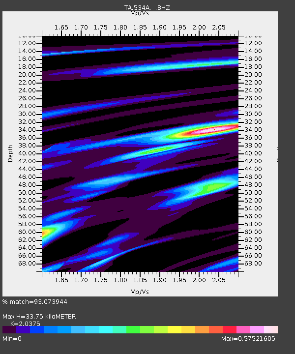
| Estimated Moho Depth: |
33.75 km |
| Estimated Crust Vp/Vs: |
2.04 |
| Assumed Crust Vp: |
6.498 km/s |
| Estimated Crust Vs: |
3.189 km/s |
| Estimated Crust Poisson's Ratio: |
0.34 |
|
| Radial Match: |
93.073944 % |
| Radial Bump: |
179 |
| Transverse Match: |
67.853096 % |
| Transverse Bump: |
393 |
| SOD ConfigId: |
339645 |
| Insert Time: |
2011-02-17 08:36:33.873 +0000 |
| GWidth: |
2.5 |
| Max Bumps: |
400 |
| Tol: |
0.001 |
|

Signal To Noise
| Channel | StoN | STA | LTA |
| TA:534A: :BHZ:20101016T20:20:49.624993Z | 11.873231 | 5.678913E-7 | 4.782955E-8 |
| TA:534A: :BHN:20101016T20:20:49.624993Z | 1.4194287 | 7.8434184E-8 | 5.525757E-8 |
| TA:534A: :BHE:20101016T20:20:49.624993Z | 4.157649 | 2.9722315E-7 | 7.148827E-8 |
| Arrivals |
| Ps | 5.5 SECOND |
| PpPs | 15 SECOND |
| PsPs/PpSs | 21 SECOND |


