You are here: Home > Network List > TA - USArray Transportable Network (new EarthScope stations) Stations List
> Station 434A Burnet, TX, USA > Earthquake Result Viewer
434A Burnet, TX, USA - Earthquake Result Viewer
| Earthquake location: |
Tonga Islands |
| Earthquake latitude/longitude: |
-20.4/-173.8 |
| Earthquake time(UTC): |
2010/10/16 (289) 20:08:30 GMT |
| Earthquake Depth: |
8.0 km |
| Earthquake Magnitude: |
6.1 MB, 5.9 MS, 5.9 MW, 5.8 MW |
| Earthquake Catalog/Contributor: |
WHDF/NEIC |
|
| Network: |
TA USArray Transportable Network (new EarthScope stations) |
| Station: |
434A Burnet, TX, USA |
| Lat/Lon: |
30.81 N/98.27 W |
| Elevation: |
462 m |
|
| Distance: |
88.6 deg |
| Az: |
56.457 deg |
| Baz: |
245.321 deg |
| Ray Param: |
0.04246181 |
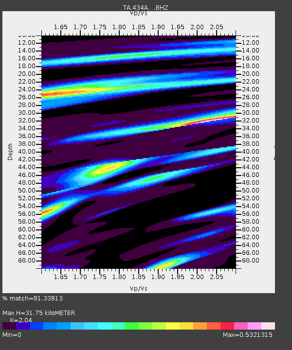
| Estimated Moho Depth: |
31.75 km |
| Estimated Crust Vp/Vs: |
2.04 |
| Assumed Crust Vp: |
6.498 km/s |
| Estimated Crust Vs: |
3.185 km/s |
| Estimated Crust Poisson's Ratio: |
0.34 |
|
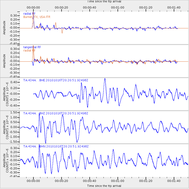
| Radial Match: |
91.33913 % |
| Radial Bump: |
246 |
| Transverse Match: |
63.16878 % |
| Transverse Bump: |
339 |
| SOD ConfigId: |
339645 |
| Insert Time: |
2011-02-17 08:36:48.731 +0000 |
| GWidth: |
2.5 |
| Max Bumps: |
400 |
| Tol: |
0.001 |
|
Signal To Noise
| Channel | StoN | STA | LTA |
| TA:434A: :BHZ:20101016T20:20:51.92498Z | 9.537399 | 5.720177E-7 | 5.997627E-8 |
| TA:434A: :BHN:20101016T20:20:51.92498Z | 3.0634725 | 1.5099702E-7 | 4.9289497E-8 |
| TA:434A: :BHE:20101016T20:20:51.92498Z | 2.2970328 | 1.659643E-7 | 7.22516E-8 |
| Arrivals |
| Ps | 5.2 SECOND |
| PpPs | 15 SECOND |
| PsPs/PpSs | 20 SECOND |


