You are here: Home > Network List > TA - USArray Transportable Network (new EarthScope stations) Stations List
> Station 334A Lometa, TX, USA > Earthquake Result Viewer
334A Lometa, TX, USA - Earthquake Result Viewer
| Earthquake location: |
Tonga Islands |
| Earthquake latitude/longitude: |
-20.4/-173.8 |
| Earthquake time(UTC): |
2010/10/16 (289) 20:08:30 GMT |
| Earthquake Depth: |
8.0 km |
| Earthquake Magnitude: |
6.1 MB, 5.9 MS, 5.9 MW, 5.8 MW |
| Earthquake Catalog/Contributor: |
WHDF/NEIC |
|
| Network: |
TA USArray Transportable Network (new EarthScope stations) |
| Station: |
334A Lometa, TX, USA |
| Lat/Lon: |
31.33 N/98.24 W |
| Elevation: |
389 m |
|
| Distance: |
88.9 deg |
| Az: |
55.998 deg |
| Baz: |
245.327 deg |
| Ray Param: |
0.04228238 |
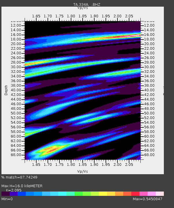
| Estimated Moho Depth: |
16.0 km |
| Estimated Crust Vp/Vs: |
2.10 |
| Assumed Crust Vp: |
6.498 km/s |
| Estimated Crust Vs: |
3.101 km/s |
| Estimated Crust Poisson's Ratio: |
0.35 |
|
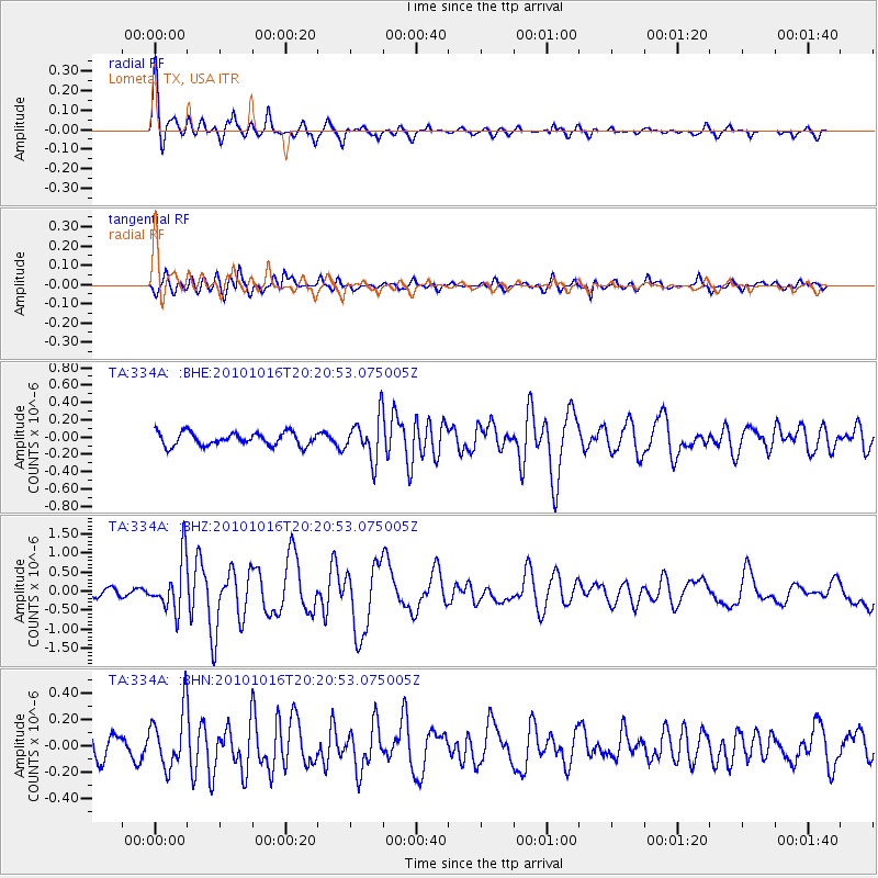
| Radial Match: |
87.74249 % |
| Radial Bump: |
365 |
| Transverse Match: |
70.80784 % |
| Transverse Bump: |
400 |
| SOD ConfigId: |
339645 |
| Insert Time: |
2011-02-17 08:37:24.578 +0000 |
| GWidth: |
2.5 |
| Max Bumps: |
400 |
| Tol: |
0.001 |
|
Signal To Noise
| Channel | StoN | STA | LTA |
| TA:334A: :BHZ:20101016T20:20:53.075005Z | 8.175821 | 6.780708E-7 | 8.293611E-8 |
| TA:334A: :BHN:20101016T20:20:53.075005Z | 1.9561402 | 2.1492997E-7 | 1.0987452E-7 |
| TA:334A: :BHE:20101016T20:20:53.075005Z | 3.2585151 | 2.4516814E-7 | 7.523922E-8 |
| Arrivals |
| Ps | 2.7 SECOND |
| PpPs | 7.5 SECOND |
| PsPs/PpSs | 10 SECOND |


