You are here: Home > Network List > AK - Alaska Regional Network Stations List
> Station C23K Itkillik River, AK, USA > Earthquake Result Viewer
C23K Itkillik River, AK, USA - Earthquake Result Viewer
| Earthquake location: |
New Britain Region, P.N.G. |
| Earthquake latitude/longitude: |
-5.8/151.1 |
| Earthquake time(UTC): |
2024/04/14 (105) 20:56:28 GMT |
| Earthquake Depth: |
49 km |
| Earthquake Magnitude: |
6.5 mww |
| Earthquake Catalog/Contributor: |
NEIC PDE/us |
|
| Network: |
AK Alaska Regional Network |
| Station: |
C23K Itkillik River, AK, USA |
| Lat/Lon: |
69.84 N/150.61 W |
| Elevation: |
179 m |
|
| Distance: |
85.0 deg |
| Az: |
17.224 deg |
| Baz: |
238.17 deg |
| Ray Param: |
0.04498808 |
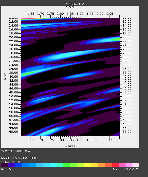
| Estimated Moho Depth: |
10.0 km |
| Estimated Crust Vp/Vs: |
1.63 |
| Assumed Crust Vp: |
6.221 km/s |
| Estimated Crust Vs: |
3.811 km/s |
| Estimated Crust Poisson's Ratio: |
0.20 |
|
| Radial Match: |
89.1946 % |
| Radial Bump: |
369 |
| Transverse Match: |
71.27637 % |
| Transverse Bump: |
381 |
| SOD ConfigId: |
34194791 |
| Insert Time: |
2024-04-28 20:59:27.611 +0000 |
| GWidth: |
2.5 |
| Max Bumps: |
400 |
| Tol: |
0.001 |
|

Signal To Noise
| Channel | StoN | STA | LTA |
| AK:C23K: :BHZ:20240414T21:08:27.41999Z | 8.482039 | 1.5271298E-6 | 1.8004278E-7 |
| AK:C23K: :BHN:20240414T21:08:27.41999Z | 1.2032267 | 2.3514372E-7 | 1.9542762E-7 |
| AK:C23K: :BHE:20240414T21:08:27.41999Z | 3.0459738 | 4.440862E-7 | 1.4579449E-7 |
| Arrivals |
| Ps | 1.0 SECOND |
| PpPs | 4.1 SECOND |
| PsPs/PpSs | 5.2 SECOND |


