You are here: Home > Network List > TA - USArray Transportable Network (new EarthScope stations) Stations List
> Station 435B Jarrell, TX, USA > Earthquake Result Viewer
435B Jarrell, TX, USA - Earthquake Result Viewer
| Earthquake location: |
Tonga Islands |
| Earthquake latitude/longitude: |
-20.4/-173.8 |
| Earthquake time(UTC): |
2010/10/16 (289) 20:08:30 GMT |
| Earthquake Depth: |
8.0 km |
| Earthquake Magnitude: |
6.1 MB, 5.9 MS, 5.9 MW, 5.8 MW |
| Earthquake Catalog/Contributor: |
WHDF/NEIC |
|
| Network: |
TA USArray Transportable Network (new EarthScope stations) |
| Station: |
435B Jarrell, TX, USA |
| Lat/Lon: |
30.78 N/97.58 W |
| Elevation: |
248 m |
|
| Distance: |
89.1 deg |
| Az: |
56.73 deg |
| Baz: |
245.675 deg |
| Ray Param: |
0.042075902 |
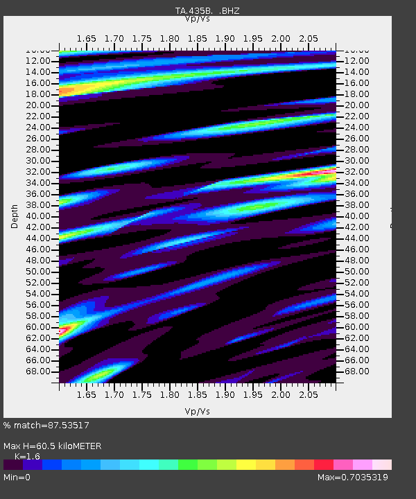
| Estimated Moho Depth: |
60.5 km |
| Estimated Crust Vp/Vs: |
1.60 |
| Assumed Crust Vp: |
6.347 km/s |
| Estimated Crust Vs: |
3.967 km/s |
| Estimated Crust Poisson's Ratio: |
0.18 |
|
| Radial Match: |
87.53517 % |
| Radial Bump: |
400 |
| Transverse Match: |
70.34446 % |
| Transverse Bump: |
400 |
| SOD ConfigId: |
339645 |
| Insert Time: |
2011-02-17 08:38:24.689 +0000 |
| GWidth: |
2.5 |
| Max Bumps: |
400 |
| Tol: |
0.001 |
|
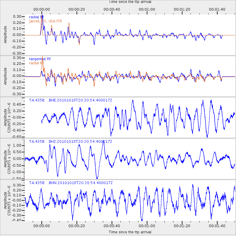
Signal To Noise
| Channel | StoN | STA | LTA |
| TA:435B: :BHZ:20101016T20:20:54.400017Z | 4.0464406 | 4.6358298E-7 | 1.1456562E-7 |
| TA:435B: :BHN:20101016T20:20:54.400017Z | 1.0999534 | 1.2047961E-7 | 1.0953156E-7 |
| TA:435B: :BHE:20101016T20:20:54.400017Z | 0.9649355 | 1.483322E-7 | 1.5372241E-7 |
| Arrivals |
| Ps | 5.9 SECOND |
| PpPs | 24 SECOND |
| PsPs/PpSs | 30 SECOND |


