You are here: Home > Network List > TA - USArray Transportable Network (new EarthScope stations) Stations List
> Station 340A Bronson, TX, USA > Earthquake Result Viewer
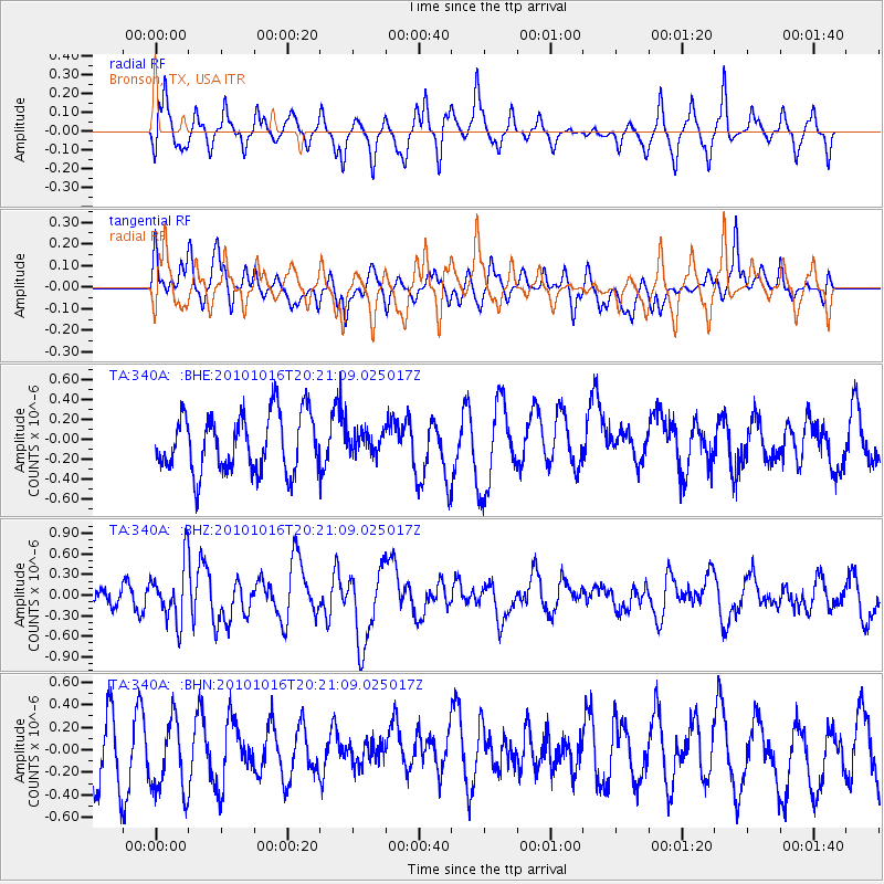
340A Bronson, TX, USA - Earthquake Result Viewer
*The percent match for this event was below the threshold and hence no stack was calculated.
| Earthquake location: |
Tonga Islands |
| Earthquake latitude/longitude: |
-20.4/-173.8 |
| Earthquake time(UTC): |
2010/10/16 (289) 20:08:30 GMT |
| Earthquake Depth: |
8.0 km |
| Earthquake Magnitude: |
6.1 MB, 5.9 MS, 5.9 MW, 5.8 MW |
| Earthquake Catalog/Contributor: |
WHDF/NEIC |
|
| Network: |
TA USArray Transportable Network (new EarthScope stations) |
| Station: |
340A Bronson, TX, USA |
| Lat/Lon: |
31.42 N/93.89 W |
| Elevation: |
57 m |
|
| Distance: |
92.3 deg |
| Az: |
57.408 deg |
| Baz: |
247.567 deg |
| Ray Param: |
$rayparam |
*The percent match for this event was below the threshold and hence was not used in the summary stack. |
|
| Radial Match: |
54.411873 % |
| Radial Bump: |
307 |
| Transverse Match: |
52.262264 % |
| Transverse Bump: |
400 |
| SOD ConfigId: |
339645 |
| Insert Time: |
2011-02-17 08:38:56.040 +0000 |
| GWidth: |
2.5 |
| Max Bumps: |
400 |
| Tol: |
0.001 |
|
Signal To Noise
| Channel | StoN | STA | LTA |
| TA:340A: :BHZ:20101016T20:21:09.025017Z | 3.509111 | 4.1986036E-7 | 1.1964865E-7 |
| TA:340A: :BHN:20101016T20:21:09.025017Z | 1.1299489 | 3.4180542E-7 | 3.0249637E-7 |
| TA:340A: :BHE:20101016T20:21:09.025017Z | 0.37096497 | 1.0735393E-7 | 2.89391E-7 |
| Arrivals |
| Ps | |
| PpPs | |
| PsPs/PpSs | |


