You are here: Home > Network List > AK - Alaska Regional Network Stations List
> Station M14K Bethel, AK, USA > Earthquake Result Viewer
M14K Bethel, AK, USA - Earthquake Result Viewer
| Earthquake location: |
New Britain Region, P.N.G. |
| Earthquake latitude/longitude: |
-5.8/151.1 |
| Earthquake time(UTC): |
2024/04/14 (105) 20:56:28 GMT |
| Earthquake Depth: |
49 km |
| Earthquake Magnitude: |
6.5 mww |
| Earthquake Catalog/Contributor: |
NEIC PDE/us |
|
| Network: |
AK Alaska Regional Network |
| Station: |
M14K Bethel, AK, USA |
| Lat/Lon: |
60.75 N/161.96 W |
| Elevation: |
19 m |
|
| Distance: |
75.8 deg |
| Az: |
21.728 deg |
| Baz: |
228.589 deg |
| Ray Param: |
0.05136116 |
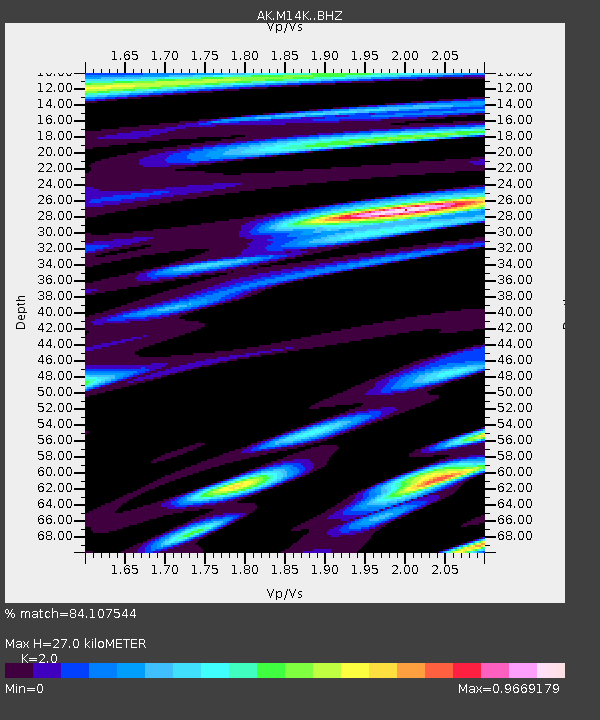
| Estimated Moho Depth: |
27.0 km |
| Estimated Crust Vp/Vs: |
2.00 |
| Assumed Crust Vp: |
6.182 km/s |
| Estimated Crust Vs: |
3.091 km/s |
| Estimated Crust Poisson's Ratio: |
0.33 |
|
| Radial Match: |
84.107544 % |
| Radial Bump: |
400 |
| Transverse Match: |
79.252525 % |
| Transverse Bump: |
400 |
| SOD ConfigId: |
34194791 |
| Insert Time: |
2024-04-28 21:01:14.575 +0000 |
| GWidth: |
2.5 |
| Max Bumps: |
400 |
| Tol: |
0.001 |
|

Signal To Noise
| Channel | StoN | STA | LTA |
| AK:M14K: :BHZ:20240414T21:07:38.000007Z | 4.459434 | 1.0407122E-6 | 2.3337314E-7 |
| AK:M14K: :BHN:20240414T21:07:38.000007Z | 1.2146815 | 2.490495E-7 | 2.0503273E-7 |
| AK:M14K: :BHE:20240414T21:07:38.000007Z | 0.5725122 | 1.4309788E-7 | 2.499473E-7 |
| Arrivals |
| Ps | 4.5 SECOND |
| PpPs | 13 SECOND |
| PsPs/PpSs | 17 SECOND |


