You are here: Home > Network List > AK - Alaska Regional Network Stations List
> Station N15K Kwethluk River, AK, USA > Earthquake Result Viewer
N15K Kwethluk River, AK, USA - Earthquake Result Viewer
| Earthquake location: |
New Britain Region, P.N.G. |
| Earthquake latitude/longitude: |
-5.8/151.1 |
| Earthquake time(UTC): |
2024/04/14 (105) 20:56:28 GMT |
| Earthquake Depth: |
49 km |
| Earthquake Magnitude: |
6.5 mww |
| Earthquake Catalog/Contributor: |
NEIC PDE/us |
|
| Network: |
AK Alaska Regional Network |
| Station: |
N15K Kwethluk River, AK, USA |
| Lat/Lon: |
60.17 N/160.09 W |
| Elevation: |
449 m |
|
| Distance: |
76.1 deg |
| Az: |
22.806 deg |
| Baz: |
230.473 deg |
| Ray Param: |
0.051141303 |
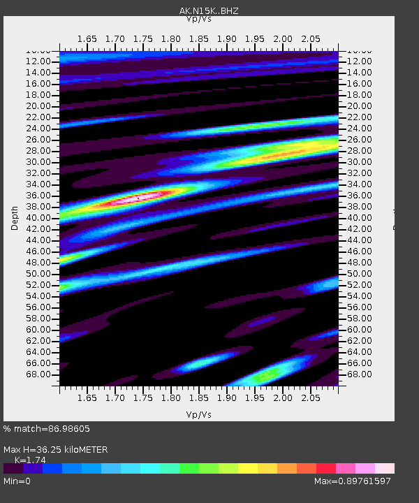
| Estimated Moho Depth: |
36.25 km |
| Estimated Crust Vp/Vs: |
1.74 |
| Assumed Crust Vp: |
6.182 km/s |
| Estimated Crust Vs: |
3.553 km/s |
| Estimated Crust Poisson's Ratio: |
0.25 |
|
| Radial Match: |
86.98605 % |
| Radial Bump: |
400 |
| Transverse Match: |
76.619026 % |
| Transverse Bump: |
400 |
| SOD ConfigId: |
34194791 |
| Insert Time: |
2024-04-28 21:01:30.167 +0000 |
| GWidth: |
2.5 |
| Max Bumps: |
400 |
| Tol: |
0.001 |
|

Signal To Noise
| Channel | StoN | STA | LTA |
| AK:N15K: :BHZ:20240414T21:07:39.839973Z | 7.1950955 | 6.6489343E-7 | 9.240926E-8 |
| AK:N15K: :BHN:20240414T21:07:39.839973Z | 1.5368673 | 2.1482015E-7 | 1.3977795E-7 |
| AK:N15K: :BHE:20240414T21:07:39.839973Z | 2.243972 | 2.6332535E-7 | 1.17347874E-7 |
| Arrivals |
| Ps | 4.5 SECOND |
| PpPs | 16 SECOND |
| PsPs/PpSs | 20 SECOND |


