You are here: Home > Network List > TA - USArray Transportable Network (new EarthScope stations) Stations List
> Station R36A Gordon, Harris, KS, USA > Earthquake Result Viewer
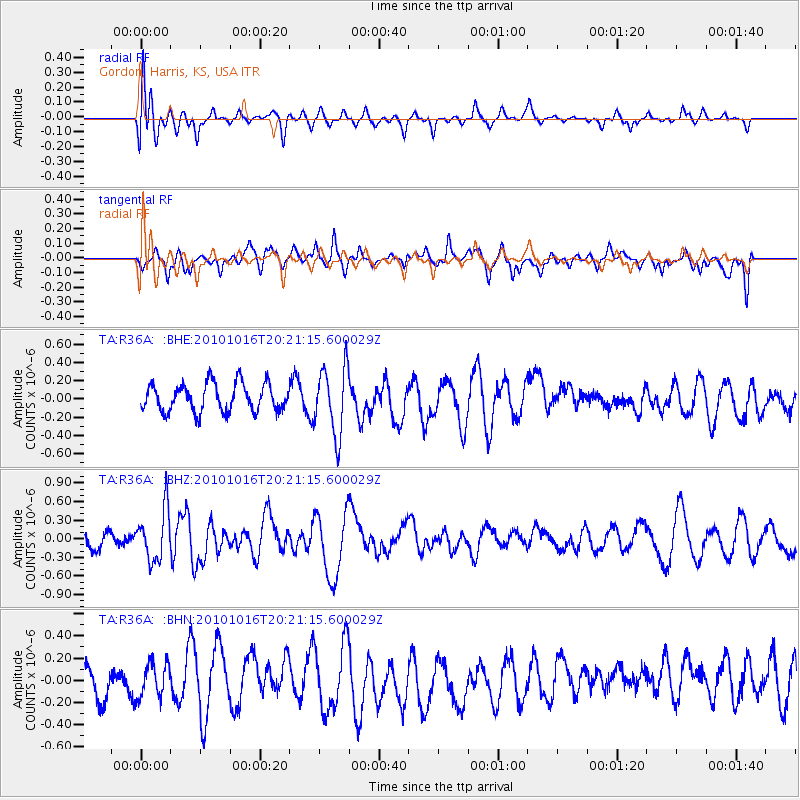
R36A Gordon, Harris, KS, USA - Earthquake Result Viewer
*The percent match for this event was below the threshold and hence no stack was calculated.
| Earthquake location: |
Tonga Islands |
| Earthquake latitude/longitude: |
-20.4/-173.8 |
| Earthquake time(UTC): |
2010/10/16 (289) 20:08:30 GMT |
| Earthquake Depth: |
8.0 km |
| Earthquake Magnitude: |
6.1 MB, 5.9 MS, 5.9 MW, 5.8 MW |
| Earthquake Catalog/Contributor: |
WHDF/NEIC |
|
| Network: |
TA USArray Transportable Network (new EarthScope stations) |
| Station: |
R36A Gordon, Harris, KS, USA |
| Lat/Lon: |
38.32 N/95.50 W |
| Elevation: |
354 m |
|
| Distance: |
93.7 deg |
| Az: |
50.529 deg |
| Baz: |
247.008 deg |
| Ray Param: |
$rayparam |
*The percent match for this event was below the threshold and hence was not used in the summary stack. |
|
| Radial Match: |
58.419617 % |
| Radial Bump: |
400 |
| Transverse Match: |
36.71777 % |
| Transverse Bump: |
377 |
| SOD ConfigId: |
339645 |
| Insert Time: |
2011-02-17 08:39:13.325 +0000 |
| GWidth: |
2.5 |
| Max Bumps: |
400 |
| Tol: |
0.001 |
|
Signal To Noise
| Channel | StoN | STA | LTA |
| TA:R36A: :BHZ:20101016T20:21:15.600029Z | 2.7328048 | 4.0624613E-7 | 1.4865537E-7 |
| TA:R36A: :BHN:20101016T20:21:15.600029Z | 0.81093717 | 1.5179097E-7 | 1.871797E-7 |
| TA:R36A: :BHE:20101016T20:21:15.600029Z | 2.4181247 | 3.6987683E-7 | 1.5296018E-7 |
| Arrivals |
| Ps | |
| PpPs | |
| PsPs/PpSs | |


