You are here: Home > Network List > TA - USArray Transportable Network (new EarthScope stations) Stations List
> Station W36A Wetumka, OK, USA > Earthquake Result Viewer
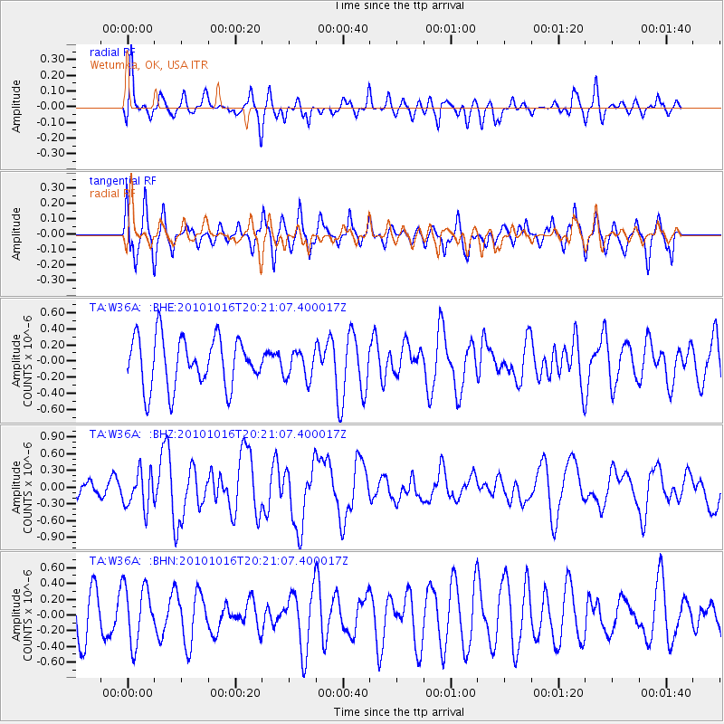
W36A Wetumka, OK, USA - Earthquake Result Viewer
*The percent match for this event was below the threshold and hence no stack was calculated.
| Earthquake location: |
Tonga Islands |
| Earthquake latitude/longitude: |
-20.4/-173.8 |
| Earthquake time(UTC): |
2010/10/16 (289) 20:08:30 GMT |
| Earthquake Depth: |
8.0 km |
| Earthquake Magnitude: |
6.1 MB, 5.9 MS, 5.9 MW, 5.8 MW |
| Earthquake Catalog/Contributor: |
WHDF/NEIC |
|
| Network: |
TA USArray Transportable Network (new EarthScope stations) |
| Station: |
W36A Wetumka, OK, USA |
| Lat/Lon: |
35.14 N/96.23 W |
| Elevation: |
251 m |
|
| Distance: |
91.9 deg |
| Az: |
53.223 deg |
| Baz: |
246.444 deg |
| Ray Param: |
$rayparam |
*The percent match for this event was below the threshold and hence was not used in the summary stack. |
|
| Radial Match: |
67.07634 % |
| Radial Bump: |
400 |
| Transverse Match: |
56.660458 % |
| Transverse Bump: |
400 |
| SOD ConfigId: |
339645 |
| Insert Time: |
2011-02-17 08:39:26.362 +0000 |
| GWidth: |
2.5 |
| Max Bumps: |
400 |
| Tol: |
0.001 |
|
Signal To Noise
| Channel | StoN | STA | LTA |
| TA:W36A: :BHZ:20101016T20:21:07.400017Z | 1.7778045 | 3.3068102E-7 | 1.8600527E-7 |
| TA:W36A: :BHN:20101016T20:21:07.400017Z | 1.3407587 | 3.644523E-7 | 2.7182543E-7 |
| TA:W36A: :BHE:20101016T20:21:07.400017Z | 0.57806283 | 1.7854092E-7 | 3.0886073E-7 |
| Arrivals |
| Ps | |
| PpPs | |
| PsPs/PpSs | |


