You are here: Home > Network List > AK - Alaska Regional Network Stations List
> Station V35K Ketchikan, AK, USA > Earthquake Result Viewer
V35K Ketchikan, AK, USA - Earthquake Result Viewer
| Earthquake location: |
New Britain Region, P.N.G. |
| Earthquake latitude/longitude: |
-5.8/151.1 |
| Earthquake time(UTC): |
2024/04/14 (105) 20:56:28 GMT |
| Earthquake Depth: |
49 km |
| Earthquake Magnitude: |
6.5 mww |
| Earthquake Catalog/Contributor: |
NEIC PDE/us |
|
| Network: |
AK Alaska Regional Network |
| Station: |
V35K Ketchikan, AK, USA |
| Lat/Lon: |
55.33 N/131.62 W |
| Elevation: |
64 m |
|
| Distance: |
87.6 deg |
| Az: |
33.915 deg |
| Baz: |
256.266 deg |
| Ray Param: |
0.043153875 |
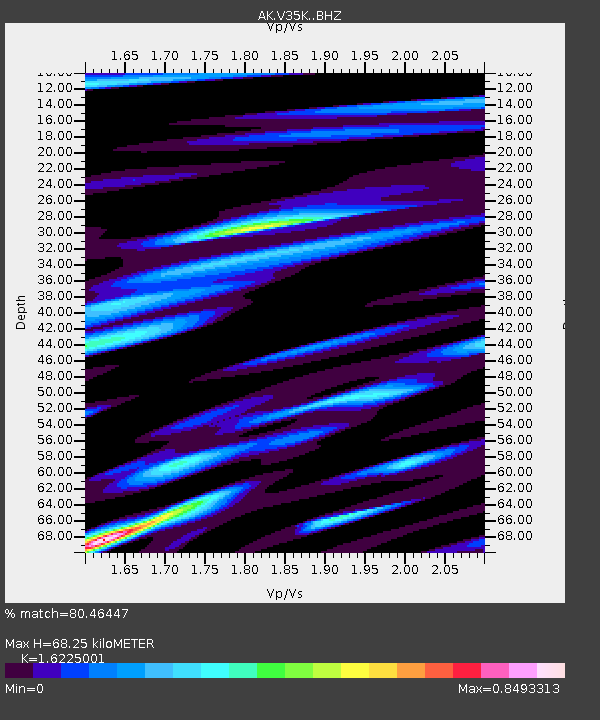
| Estimated Moho Depth: |
68.25 km |
| Estimated Crust Vp/Vs: |
1.62 |
| Assumed Crust Vp: |
6.545 km/s |
| Estimated Crust Vs: |
4.034 km/s |
| Estimated Crust Poisson's Ratio: |
0.19 |
|
| Radial Match: |
80.46447 % |
| Radial Bump: |
400 |
| Transverse Match: |
70.54549 % |
| Transverse Bump: |
400 |
| SOD ConfigId: |
34194791 |
| Insert Time: |
2024-04-28 21:02:29.001 +0000 |
| GWidth: |
2.5 |
| Max Bumps: |
400 |
| Tol: |
0.001 |
|

Signal To Noise
| Channel | StoN | STA | LTA |
| AK:V35K: :BHZ:20240414T21:08:39.89997Z | 3.4124978 | 7.818795E-7 | 2.2912235E-7 |
| AK:V35K: :BHN:20240414T21:08:39.89997Z | 0.95900536 | 1.4869302E-7 | 1.550492E-7 |
| AK:V35K: :BHE:20240414T21:08:39.89997Z | 2.983986 | 3.754879E-7 | 1.2583435E-7 |
| Arrivals |
| Ps | 6.7 SECOND |
| PpPs | 27 SECOND |
| PsPs/PpSs | 33 SECOND |


