You are here: Home > Network List > TA - USArray Transportable Network (new EarthScope stations) Stations List
> Station G32A Webster, SD, USA > Earthquake Result Viewer
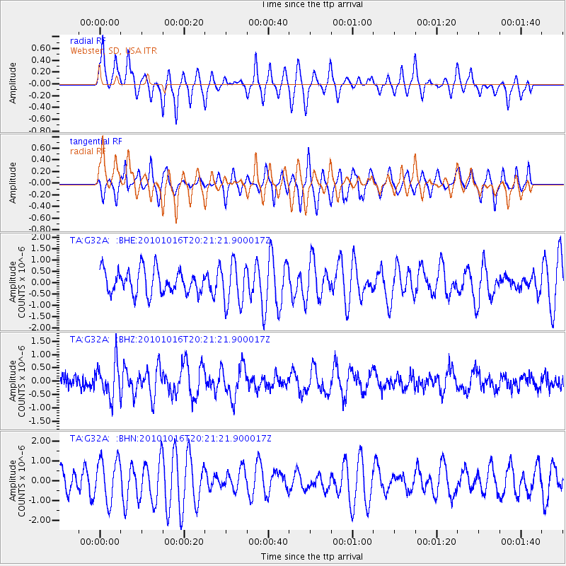
G32A Webster, SD, USA - Earthquake Result Viewer
*The percent match for this event was below the threshold and hence no stack was calculated.
| Earthquake location: |
Tonga Islands |
| Earthquake latitude/longitude: |
-20.4/-173.8 |
| Earthquake time(UTC): |
2010/10/16 (289) 20:08:30 GMT |
| Earthquake Depth: |
8.0 km |
| Earthquake Magnitude: |
6.1 MB, 5.9 MS, 5.9 MW, 5.8 MW |
| Earthquake Catalog/Contributor: |
WHDF/NEIC |
|
| Network: |
TA USArray Transportable Network (new EarthScope stations) |
| Station: |
G32A Webster, SD, USA |
| Lat/Lon: |
45.26 N/97.50 W |
| Elevation: |
566 m |
|
| Distance: |
95.1 deg |
| Az: |
43.559 deg |
| Baz: |
246.219 deg |
| Ray Param: |
$rayparam |
*The percent match for this event was below the threshold and hence was not used in the summary stack. |
|
| Radial Match: |
64.61469 % |
| Radial Bump: |
351 |
| Transverse Match: |
41.542946 % |
| Transverse Bump: |
326 |
| SOD ConfigId: |
339645 |
| Insert Time: |
2011-02-17 08:42:31.511 +0000 |
| GWidth: |
2.5 |
| Max Bumps: |
400 |
| Tol: |
0.001 |
|
Signal To Noise
| Channel | StoN | STA | LTA |
| TA:G32A: :BHZ:20101016T20:21:21.900017Z | 3.4269092 | 6.5272104E-7 | 1.9046932E-7 |
| TA:G32A: :BHN:20101016T20:21:21.900017Z | 1.4749845 | 1.0791036E-6 | 7.3160334E-7 |
| TA:G32A: :BHE:20101016T20:21:21.900017Z | 1.7615267 | 9.3018855E-7 | 5.2805814E-7 |
| Arrivals |
| Ps | |
| PpPs | |
| PsPs/PpSs | |


