You are here: Home > Network List > US - United States National Seismic Network Stations List
> Station WVOR Wild Horse Valley, Oregon, USA > Earthquake Result Viewer
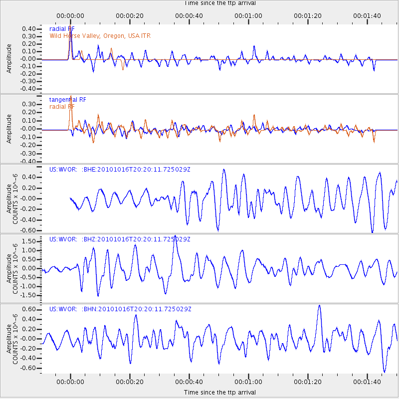
WVOR Wild Horse Valley, Oregon, USA - Earthquake Result Viewer
*The percent match for this event was below the threshold and hence no stack was calculated.
| Earthquake location: |
Tonga Islands |
| Earthquake latitude/longitude: |
-20.4/-173.8 |
| Earthquake time(UTC): |
2010/10/16 (289) 20:08:30 GMT |
| Earthquake Depth: |
8.0 km |
| Earthquake Magnitude: |
6.1 MB, 5.9 MS, 5.9 MW, 5.8 MW |
| Earthquake Catalog/Contributor: |
WHDF/NEIC |
|
| Network: |
US United States National Seismic Network |
| Station: |
WVOR Wild Horse Valley, Oregon, USA |
| Lat/Lon: |
42.43 N/118.64 W |
| Elevation: |
1344 m |
|
| Distance: |
80.6 deg |
| Az: |
38.041 deg |
| Baz: |
231.329 deg |
| Ray Param: |
$rayparam |
*The percent match for this event was below the threshold and hence was not used in the summary stack. |
|
| Radial Match: |
79.59682 % |
| Radial Bump: |
400 |
| Transverse Match: |
63.193295 % |
| Transverse Bump: |
400 |
| SOD ConfigId: |
339645 |
| Insert Time: |
2011-02-17 08:44:01.038 +0000 |
| GWidth: |
2.5 |
| Max Bumps: |
400 |
| Tol: |
0.001 |
|
Signal To Noise
| Channel | StoN | STA | LTA |
| US:WVOR: :BHZ:20101016T20:20:11.725029Z | 5.2382526 | 4.381284E-7 | 8.364018E-8 |
| US:WVOR: :BHN:20101016T20:20:11.725029Z | 1.146956 | 1.2726201E-7 | 1.10956314E-7 |
| US:WVOR: :BHE:20101016T20:20:11.725029Z | 0.57300866 | 6.1863666E-8 | 1.0796288E-7 |
| Arrivals |
| Ps | |
| PpPs | |
| PsPs/PpSs | |


