You are here: Home > Network List > S1 - Australian Seismometers in Schools Stations List
> Station AUMBR Murray Bridge High School > Earthquake Result Viewer
AUMBR Murray Bridge High School - Earthquake Result Viewer
| Earthquake location: |
New Britain Region, P.N.G. |
| Earthquake latitude/longitude: |
-5.8/151.1 |
| Earthquake time(UTC): |
2024/04/14 (105) 20:56:28 GMT |
| Earthquake Depth: |
49 km |
| Earthquake Magnitude: |
6.5 mww |
| Earthquake Catalog/Contributor: |
NEIC PDE/us |
|
| Network: |
S1 Australian Seismometers in Schools |
| Station: |
AUMBR Murray Bridge High School |
| Lat/Lon: |
35.13 S/139.29 E |
| Elevation: |
50 m |
|
| Distance: |
31.1 deg |
| Az: |
198.928 deg |
| Baz: |
23.189 deg |
| Ray Param: |
0.07909848 |
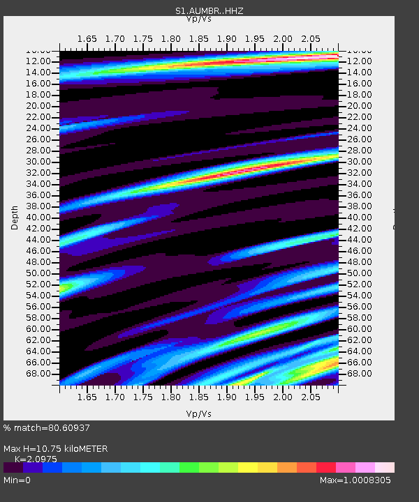
| Estimated Moho Depth: |
10.75 km |
| Estimated Crust Vp/Vs: |
2.10 |
| Assumed Crust Vp: |
6.576 km/s |
| Estimated Crust Vs: |
3.135 km/s |
| Estimated Crust Poisson's Ratio: |
0.35 |
|
| Radial Match: |
80.60937 % |
| Radial Bump: |
375 |
| Transverse Match: |
58.963627 % |
| Transverse Bump: |
400 |
| SOD ConfigId: |
34194791 |
| Insert Time: |
2024-04-28 21:16:57.153 +0000 |
| GWidth: |
2.5 |
| Max Bumps: |
400 |
| Tol: |
0.001 |
|

Signal To Noise
| Channel | StoN | STA | LTA |
| S1:AUMBR: :HHZ:20240414T21:02:12.180Z | 4.449869 | 2.8922639E-6 | 6.4996607E-7 |
| S1:AUMBR: :HHN:20240414T21:02:12.180Z | 4.9828463 | 1.6623252E-6 | 3.3360953E-7 |
| S1:AUMBR: :HHE:20240414T21:02:12.180Z | 1.4191201 | 6.7498223E-7 | 4.7563435E-7 |
| Arrivals |
| Ps | 1.9 SECOND |
| PpPs | 4.7 SECOND |
| PsPs/PpSs | 6.6 SECOND |


