You are here: Home > Network List > TA - USArray Transportable Network (new EarthScope stations) Stations List
> Station P32A Huiting Farm, Downs, KS, USA > Earthquake Result Viewer
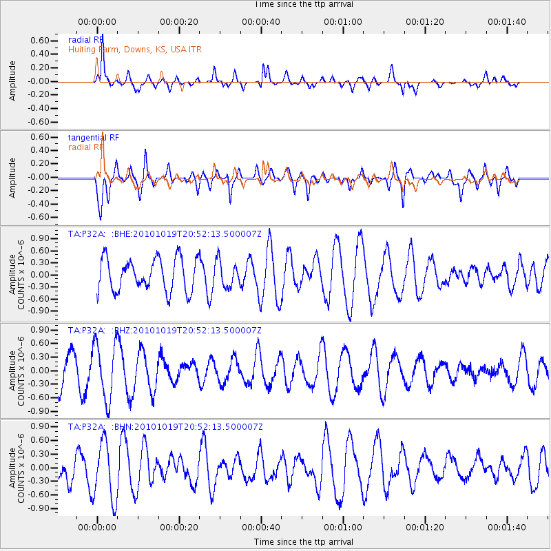
P32A Huiting Farm, Downs, KS, USA - Earthquake Result Viewer
*The percent match for this event was below the threshold and hence no stack was calculated.
| Earthquake location: |
Tonga Islands |
| Earthquake latitude/longitude: |
-20.3/-173.8 |
| Earthquake time(UTC): |
2010/10/19 (292) 20:39:36 GMT |
| Earthquake Depth: |
10 km |
| Earthquake Magnitude: |
5.6 MB, 5.1 MS, 5.2 MW |
| Earthquake Catalog/Contributor: |
WHDF/NEIC |
|
| Network: |
TA USArray Transportable Network (new EarthScope stations) |
| Station: |
P32A Huiting Farm, Downs, KS, USA |
| Lat/Lon: |
39.62 N/98.60 W |
| Elevation: |
524 m |
|
| Distance: |
92.0 deg |
| Az: |
48.338 deg |
| Baz: |
245.18 deg |
| Ray Param: |
$rayparam |
*The percent match for this event was below the threshold and hence was not used in the summary stack. |
|
| Radial Match: |
71.453445 % |
| Radial Bump: |
382 |
| Transverse Match: |
52.834194 % |
| Transverse Bump: |
400 |
| SOD ConfigId: |
339645 |
| Insert Time: |
2011-02-17 08:53:50.908 +0000 |
| GWidth: |
2.5 |
| Max Bumps: |
400 |
| Tol: |
0.001 |
|
Signal To Noise
| Channel | StoN | STA | LTA |
| TA:P32A: :BHZ:20101019T20:52:13.500007Z | 2.0713828 | 6.412417E-7 | 3.095718E-7 |
| TA:P32A: :BHN:20101019T20:52:13.500007Z | 2.0652955 | 6.539143E-7 | 3.166202E-7 |
| TA:P32A: :BHE:20101019T20:52:13.500007Z | 0.7954008 | 3.2047555E-7 | 4.0291079E-7 |
| Arrivals |
| Ps | |
| PpPs | |
| PsPs/PpSs | |


