You are here: Home > Network List > TA - USArray Transportable Network (new EarthScope stations) Stations List
> Station 133A Hamilton Ranch, Breckenridge, TX, USA > Earthquake Result Viewer
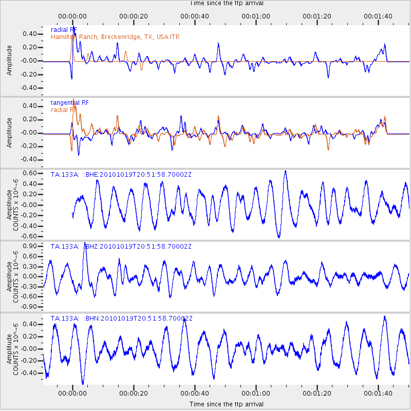
133A Hamilton Ranch, Breckenridge, TX, USA - Earthquake Result Viewer
*The percent match for this event was below the threshold and hence no stack was calculated.
| Earthquake location: |
Tonga Islands |
| Earthquake latitude/longitude: |
-20.3/-173.8 |
| Earthquake time(UTC): |
2010/10/19 (292) 20:39:36 GMT |
| Earthquake Depth: |
10 km |
| Earthquake Magnitude: |
5.6 MB, 5.1 MS, 5.2 MW |
| Earthquake Catalog/Contributor: |
WHDF/NEIC |
|
| Network: |
TA USArray Transportable Network (new EarthScope stations) |
| Station: |
133A Hamilton Ranch, Breckenridge, TX, USA |
| Lat/Lon: |
32.61 N/98.92 W |
| Elevation: |
418 m |
|
| Distance: |
88.8 deg |
| Az: |
54.577 deg |
| Baz: |
244.955 deg |
| Ray Param: |
$rayparam |
*The percent match for this event was below the threshold and hence was not used in the summary stack. |
|
| Radial Match: |
56.973232 % |
| Radial Bump: |
400 |
| Transverse Match: |
64.402725 % |
| Transverse Bump: |
400 |
| SOD ConfigId: |
339645 |
| Insert Time: |
2011-02-17 08:54:05.411 +0000 |
| GWidth: |
2.5 |
| Max Bumps: |
400 |
| Tol: |
0.001 |
|
Signal To Noise
| Channel | StoN | STA | LTA |
| TA:133A: :BHZ:20101019T20:51:58.70002Z | 1.9696069 | 4.5567808E-7 | 2.3135483E-7 |
| TA:133A: :BHN:20101019T20:51:58.70002Z | 1.3342805 | 3.0578758E-7 | 2.2917787E-7 |
| TA:133A: :BHE:20101019T20:51:58.70002Z | 0.99760777 | 2.4877508E-7 | 2.4937162E-7 |
| Arrivals |
| Ps | |
| PpPs | |
| PsPs/PpSs | |


