You are here: Home > Network List > AK - Alaska Regional Network Stations List
> Station E24K Your Creek, AK, USA > Earthquake Result Viewer
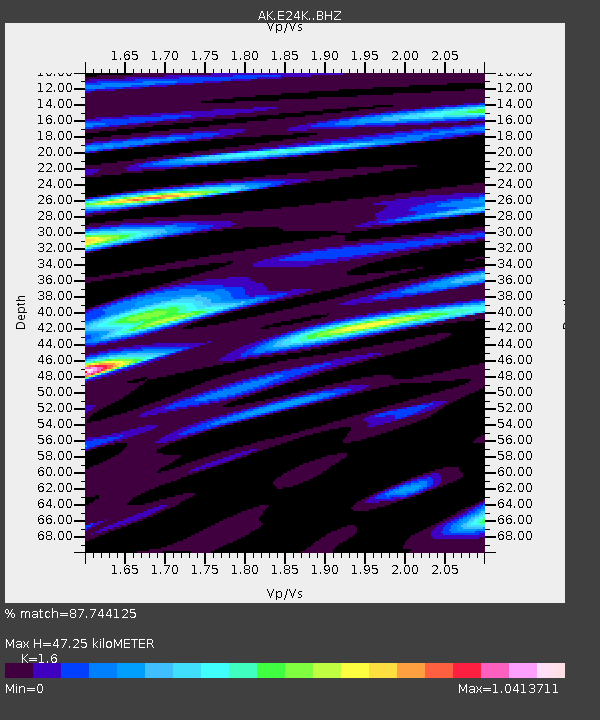
E24K Your Creek, AK, USA - Earthquake Result Viewer
| Earthquake location: |
Southeast Of Ryukyu Islands |
| Earthquake latitude/longitude: |
29.5/131.7 |
| Earthquake time(UTC): |
2024/04/15 (106) 22:38:57 GMT |
| Earthquake Depth: |
8.0 km |
| Earthquake Magnitude: |
5.9 mww |
| Earthquake Catalog/Contributor: |
NEIC PDE/us |
|
| Network: |
AK Alaska Regional Network |
| Station: |
E24K Your Creek, AK, USA |
| Lat/Lon: |
68.07 N/148.49 W |
| Elevation: |
847 m |
|
| Distance: |
59.2 deg |
| Az: |
25.48 deg |
| Baz: |
272.695 deg |
| Ray Param: |
0.06234271 |
| Estimated Moho Depth: |
47.25 km |
| Estimated Crust Vp/Vs: |
1.60 |
| Assumed Crust Vp: |
6.316 km/s |
| Estimated Crust Vs: |
3.948 km/s |
| Estimated Crust Poisson's Ratio: |
0.18 |
|
| Radial Match: |
87.744125 % |
| Radial Bump: |
340 |
| Transverse Match: |
72.73744 % |
| Transverse Bump: |
400 |
| SOD ConfigId: |
34194791 |
| Insert Time: |
2024-04-29 22:43:35.810 +0000 |
| GWidth: |
2.5 |
| Max Bumps: |
400 |
| Tol: |
0.001 |
|

Signal To Noise
| Channel | StoN | STA | LTA |
| AK:E24K: :BHZ:20240415T22:48:27.580023Z | 11.784324 | 1.0802859E-6 | 9.167143E-8 |
| AK:E24K: :BHN:20240415T22:48:27.580023Z | 1.4290633 | 9.4038505E-8 | 6.58043E-8 |
| AK:E24K: :BHE:20240415T22:48:27.580023Z | 4.5810747 | 4.1864115E-7 | 9.138492E-8 |
| Arrivals |
| Ps | 4.7 SECOND |
| PpPs | 18 SECOND |
| PsPs/PpSs | 23 SECOND |


